Author: Oleksii Korotia (Олексій Коротя)
Since 2020, the reserve has been implementing a project to use laser scanning to study archaeological sites within the territory of the Bilsk Archaeological Complex. During the course of this work, a laser scanning methodology was developed and optimised, including the testing of various devices.
In 2023, Oleksii Korotia, Deputy Director for Scientific and Excursion Activities of the Bilsk Historical and Cultural Reserve, conducted laser scanning research at three sites: the Kotelva hillfort, and the Eastern and Kuzemin fortifications of the Bilsk hillfort.
Most of the territory encompassing the investigated sites (Fig. 1) is forested, which complicates topographic and geodetic work required to produce modern topographic plans of the archaeological monuments and renders it impossible to create orthophotographs of the aforementioned sites. Compared to other remote sensing methods, a key feature of LiDAR scanning is its high density of measurements per square metre and its superior accuracy relative to photogrammetric techniques.
For this project, we used LiDAR equipment manufactured by YellowScan (model Vx-15), mounted on a multi-rotor UAV, as well as a handheld scanner (Stonex X120GO) (Fig. 2). These two models provide point cloud accuracy of up to 2.5 cm after processing. To verify the accuracy of the survey, ground control points (GCPs) were established at each site, with coordinates recorded using a Leica GS07 GNSS receiver in RTK mode. All laser scanning and control point surveying was conducted using the UCS 2000 coordinate system (EPSG:5564).
The resulting point cloud from the laser scanning was classified using Cube-3D software, and a land surface class was identified. Based on this, a digital elevation model of the monument was created (Fig. 3).
In total, 213 hectares of the monuments were surveyed in 2023. Due to the large area of the Eastern fortification and the Kotelva hillfort (211 hectares), the YellowScan laser scanner was used for their documentation. The Kuzemin fortifications, covering an area of 2.3 hectares, were surveyed using the handheld Stonex laser scanner.
UAV-based LiDAR has proven highly effective for studying large and complex archaeological sites located in forested areas. The handheld laser scanner has likewise demonstrated its effectiveness on smaller sites of up to 5 hectares.
The high-resolution digital elevation models and three-dimensional representations of the sites (Fig. 4), produced as part of this project, will serve as the basis for creating accurate topographic plans in future work. The 3D models of the investigated sites are available on the Sketchfab platform via the Bilsk Conservation Area account:
- Kotelva hillfort – https://skfb.ly/oXPZu
- Kuzemin fortification – https://skfb.ly/oXQnu
- Eastern fortification – https://skfb.ly/oXPVB
The detailed research findings will be presented in a series of scientific publications and will also form the basis for further investigations of these monuments.
Oleksii Korotia
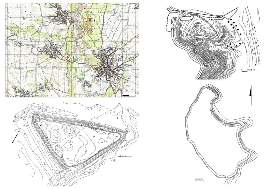
Fig. 1: Kotelva hillfort, the Eastern and Kuzemin fortifications plan (by Oleksii Korotia).
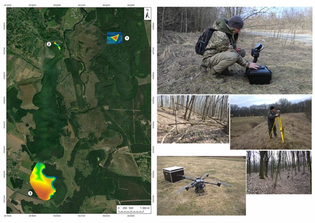
Fig. 2: Research of the Kotelva hillfort, the Eastern and Kuzemin fortifications (photograph: Oleh Shaporda, Oleksii Korotia).
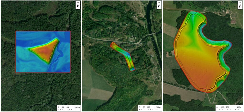
Fig. 3: Kotelva hillfort, the Eastern and Kuzemin fortifications digital elevation models (by Oleksii Korotia).
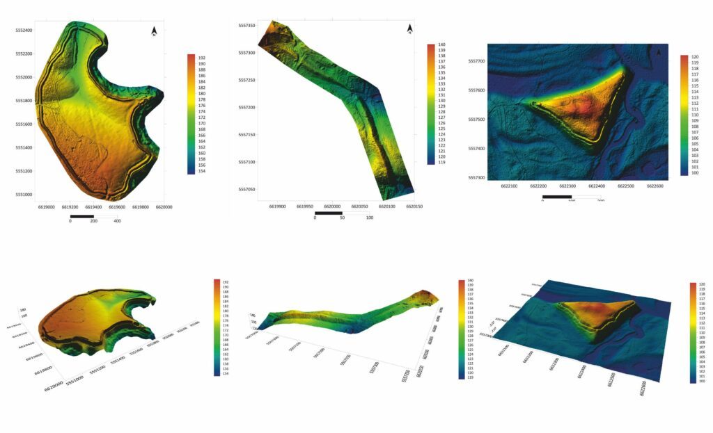
Fig. 4: Kotelva hillfort, the Eastern and Kuzemin fortifications digital elevation models and three-dimensional models (by Oleksii Korotia).
About the author:
Oleksii Korotia (Олексій Коротя) is a Ukrainian archaeologist specialising in the Bilsk hillfort and its fortifications. In 2020, he defended his PhD (Candidate of Historical Sciences) at the Institute of Archaeology of the National Academy of Sciences of Ukraine. His dissertation focused on the defensive structures of Scythian-period sites in the Dnipro–Donets Forest‑Steppe region. His recent publications from 2024 include articles in the journal Konsensus, such as “Study of the Kuzemin Fortification of the Bilsk Settlement Using LiDAR” and “Localization of the Bilsk Transportation According to Archaeological Research and Remote Sensing”, both listing him as principal author.