P07 „Routes of Interaction“ – What happened in the meantime?
In the second funding phase, the interdisciplinary research project is continuing to investigate intra-African contacts between the northern Horn of Africa, the Middle Nile, the northeastern Sudanese Gash Delta and parts of Egypt. The Rama area, located in the Ethiopian-Eritrean border area, as a supraregional contact corridor between the Eritrean-Ethiopian highlands and the Gash Delta is the focus of our research.
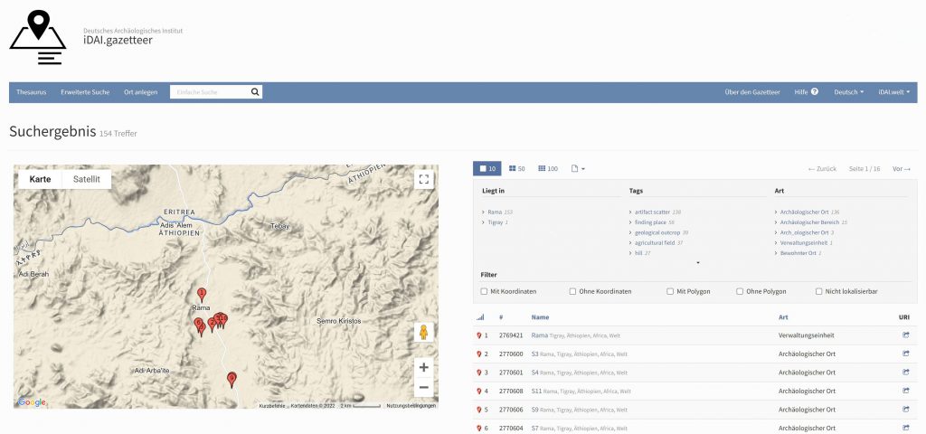
Because of the civil war and the Covid-19 pandemic, no further fieldwork could be carried out after 2019. Therefore, research and processing activities were intensified and previously collected field data were transferred into open-access repositories of idai.welt for long-term archiving and accessibility of research data. Accordingly, all survey data were included in idai.gazetteer (Fig. 1) and the finds data in idai.objects. The release of this data is being planned in close coordination with the Ethiopian authorities.
Fig. 1 iDAI.gazetteer screenshot of data entries of the surveyed sites in the Rama valley (Attribution & Copyright: DAI)
Sites in northern Ethiopia often show a centuries-long, if not millennia-long, settlement continuity or development of one and the same place. This also applies to churches and monasteries. Thus, Aksumite and pre-Aksumite sites can usually be considered as indicators of earlier settlements. Against this background, extensive mapping of churches and monasteries in Tigray in Ethiopia and in adjacent Eritrea, including the documentation of their geographical and topographical conditions, was carried out by analysing satellite images. With the help of published coordinates of ancient sites, the data are currently being evaluated and will then serve as further parameters for least-cost path models. This work is supported by the ongoing studies of historical maps and travel reports. On a broad methodological basis, research is being conducted on the mobility systems, settlement patterns and communication routes in the Ethiopian highlands. Studies on networks with the neighbouring regions were continued through team meetings and workshops with research projects in Sudan and the Horn of Africa.
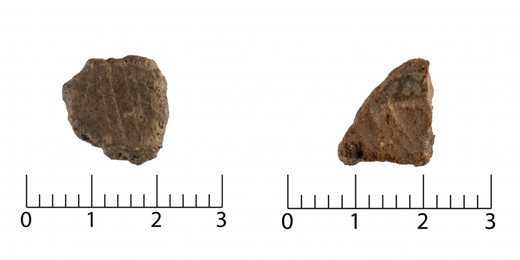
Fig. 2 Dated potsherd samples from the excavated site “Gual Kor Nebri” (S40-A). (Attribution & Copyright: I. Wagner, DAI)
In addition to the research on path systems, assemblages are also essential for the detection of supraregional interaction. Clay figurines, obsidian artefacts and pottery are important indicators of cultural contacts between the different regions. Potsherds found during archaeological sondages at the site “Gual Kor Nebri” in the Rama area in 2019 show a characteristic combination of very fine, impressed and incised decorations on the rim- and body sherds. This type of ceramic decoration is comparable to that on vessels dating to the period between the 4th and 1st millennium BC from Sudan and the Gash region. Recent results of thermoluminescence dating (OSL/TL research laboratory of the University of Cologne) of the sherds confirm an age of 3.71 ± 0.32 ka BP and 3.22 ± 0.24 ka BP (Fig. 2) and thus attest to close contacts with the eastern Sudanese lowlands in the 2nd millennium BC. Further comparative studies on assemblages from Sudan, but also from Egypt, Eritrea and Somalia are currently being carried out.
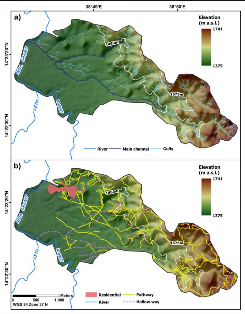
In the physical geography component of the interdisciplinary research project, initial research on the interplay between pathway systems and gully erosion has been completed. The spatial relationship between the formation of gullies and the distance to settlements and footpaths was investigated (Fig. 3). These can be seen as typical factors of human interaction with the natural environment in rural areas of Africa. Within a larger region around the Rama area in the northern Ethiopian highlands, 16 environmental and human-related variables were mapped and categorized. By including algorithms and human-related and environmental factors, models were created on the basis of which changes could be recognized, compared and evaluated. One result of the study is that almost 30% of the mapped gullies can be traced back to anthropogenic environmental influences.
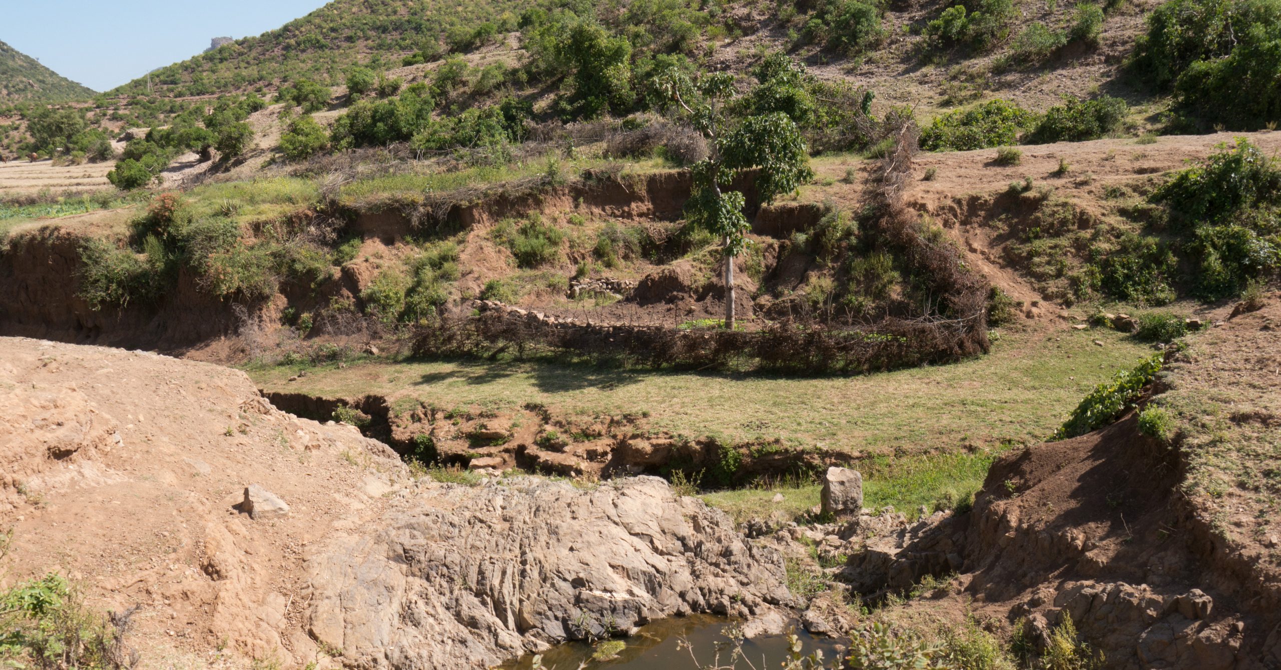
In addition, feedback effects between the use of footpaths and gully erosion were investigated using statistical model calculations. Based on the premise that the continuous use of a footpath leads to soil compaction, which triggers gully erosion under certain geomorphological conditions, the original pathway is destroyed because of the headward erosion of the gully and the path must be repeatedly relocated, which can require drastic adjustments to the route, especially in hilly terrain.
Furthermore, the influence of trampling and the resulting soil compaction on the physical and chemical soil properties was investigated. Micromorphological analyses, pedological laboratory works and GIS-supported geomorphological analyses were applied. Immediately below the surface of the footpath, especially the number of macropores is greatly reduced. At the same time the pedogenic iron contents are significantly increased, compared to the control group. Under certain conditions, when footpaths have incised so that they form holloways, these holloways can reduce the formation of gullies, as the paths themselves serve as a channel for surface runoff.
Fig. 3 Overview map of the studied catchment area near the Rama valley and the main stream (river) to which the watershed streams are tributary (ALOS Global DSM). (a) includes the drainage network, differentiated into gullies, main channels and rivers. The white line marks the local topography-based division into lowlands (1575 m a.s.l.). (b) shows areas of human interaction (residential areas, pathways and holloways). (Attribution & Copyright: R. Busch, FU Berlin, CC-BY-4.0)
This website uses cookies to improve your experience while you navigate through the website. Out of these, the cookies that are categorized as necessary are stored on your browser as they are essential for the working of basic functionalities of the website. We also use third-party cookies that help us analyze and understand how you use this website. These cookies will be stored in your browser only with your consent. You also have the option to opt-out of these cookies. But opting out of some of these cookies may affect your browsing experience.
Necessary cookies are absolutely essential for the website to function properly. This category only includes cookies that ensures basic functionalities and security features of the website. These cookies do not store any personal information.
Any cookies that may not be particularly necessary for the website to function and is used specifically to collect user personal data via analytics, ads, other embedded contents are termed as non-necessary cookies. It is mandatory to procure user consent prior to running these cookies on your website.