Phoenicians in Morocco - Environmental Factors
Due to the Corona pandemic, archaeological fieldwork in Morocco was not possible during the past few years. Nonetheless, it is possible to highlight positive aspects, as this time has given us an opportunity to prepare future research projects in advance in a targeted manner. Furthermore, we have been able to obtain novel scientific information that cannot be gathered through fieldwork alone.
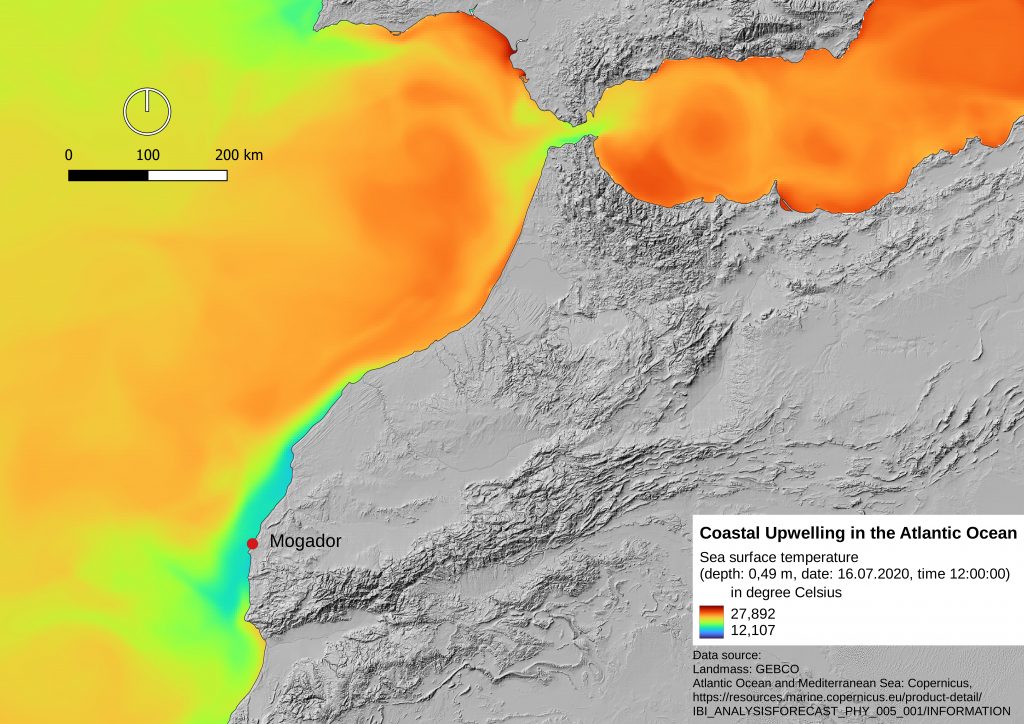
At the moment, the work in Northwest Africa is concentrated on the area of Morocco and is specifically focused on the Phoenician expansion phase (9th-7th century BCE) to the West during the Early Iron Age. The goal is to build a GIS system for this region and time frame. This system shall be kept open and expandable on a regional and temporal level. In addition to terrestrial satellite imagery, satellite imagery of the Atlantic Ocean and the Mediterranean Sea will be explored and evaluated in the course of our research. Terrestrial remote sensing data can be used, for example, to develop terrain models in various resolutions, from which calculations of terrain topography can then be derived. Examples include hydrological modelling or morphological terrain classification. Satellite images of the oceans reveal details regarding wind and ocean currents, which are relevant, especially for seafaring cultures such as the Phoenicians. Satellite observations of ocean temperatures can even provide clues to locations with particular marine resources. In addition to searching for suitable satellite imagery, a GIS site database is being developed in parallel to contextualize the archaeological information with the remote sensing data. Furthermore, special attention is given to the mapping of resources that were of interest to Phoenician traders during the Iron Age (e.g. metal deposits). In cooperation with the FU Berlin, work has also begun on collecting data on soil quality, vegetation and geology.
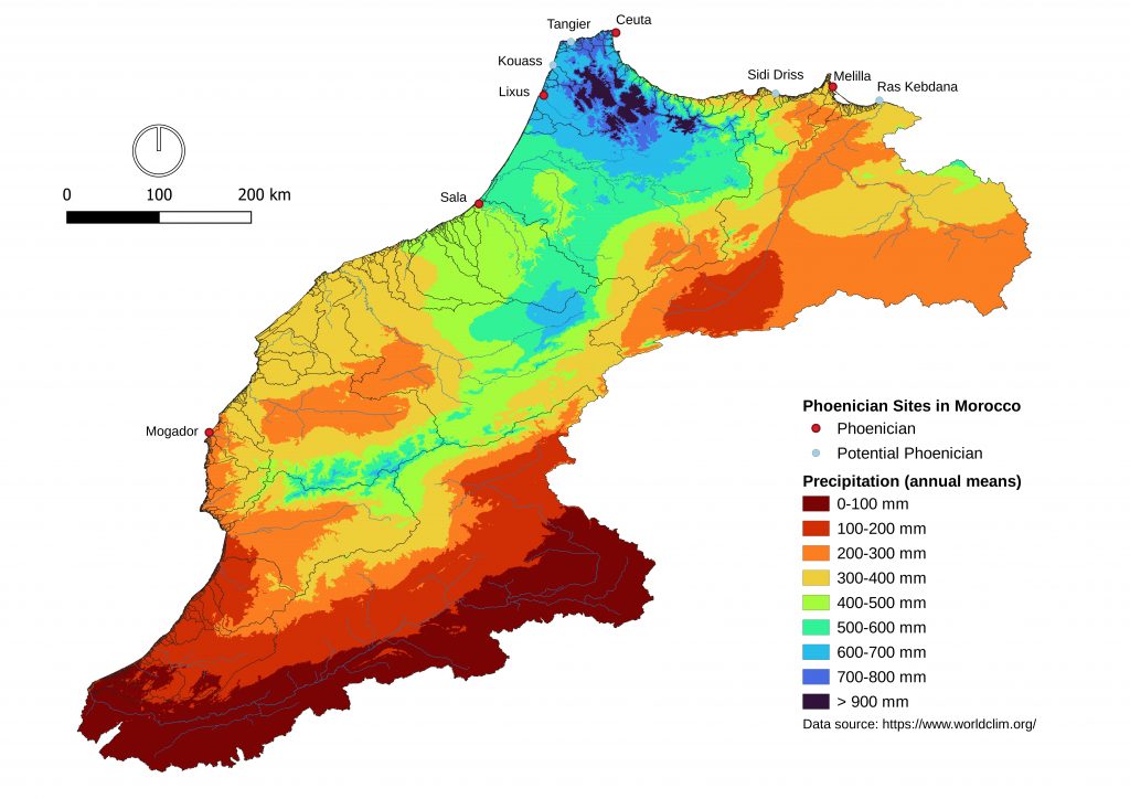
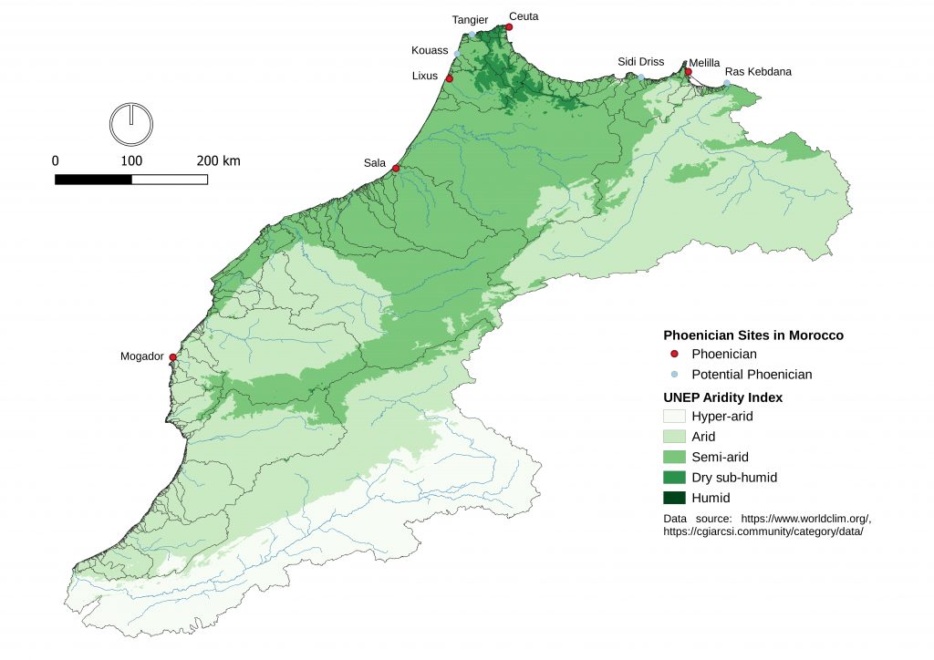
People have needed to, and continue to adapt to the diverse climatic conditions of Northwest Africa. The north and south coasts are exposed to Mediterranean and Atlantic influences. The Atlas Mountains, which run from southwest to northeast Morocco form a watershed that provides an arid climate in the south and east of the country and a semi-arid/humid climate in the northwest. Initially, it will be possible to assume that sufficient water resources must have provided good conditions for settlement locations. Especially along the Atlantic coast many Phoenician stations have been identified indicating a preference to settle near the mouths of large permanent water-bearing river systems, as are the cases of Lixus on the Loukkos, Sala on the Bou Regreg, or Mogador on the Oued Ksob. The special importance of Lixus in Phoenician times may also be due to its extremely favourable geographical situation in the estuary of a larger catchment area of 3765 sq. km with rainfalls of approximately 800mm/year. The southernmost Phoenician station on the Atlantic coast was Mogador at the foot of the Oued Ksob, whose catchment area reaches a size of 1744 sq. km and has an average precipitation of 300 mm/year. Although this region can be described as arid/semi-arid climatically, it is still possible to grow rain-fed crops in the area without using artificial irrigation systems. The lower threshold for optimal wheat cultivation is about 250 mm/year. Excavation finds of charred wheat grains on the island of Mogador in the Phoenician layers does not prove cultivation on site, but there could have been a connection between climatic conditions and a permanent presence of Phoenician traders.
Along the Mediterranean coast, the situation is somewhat different. The catchment areas here are generally much smaller due to the geomorphological conditions of the terrain with the exception for the Moulouya river valley. No Phoenician sites have been found so far directly at the mouths of larger rivers such as the Oued Martíl (catchment area of 1157 sq. km), though it may also be a consequence of research in the area. Potential evidence of Phoenician presence at Ras Kebdana, seven kilometres from the mouth of the Moulouya River, Morocco’s second largest drainage basin (66590 sq. km), is indicative of a Phoenician strategy in site selection aimed at maximizing access to the hinterland. However, there is another point to be added, namely the control over strategically important locations. The Phoenician site at Ceuta, located directly opposite Gibraltar, is situated on a narrow passage separating an island with a mountain called “Monte Hacho” from the Moroccan mainland. The nearest estuary with sufficient water flow is about three to four kilometers away, being the Tarajal-River. It was not until Roman times that a connection was created between the two points by means of an aqueduct, which guaranteed a sufficient water supply for the citizens of ancient Ceuta. How Ceuta’s water supply was secured in Phoenician times is still unclear. Whether or not the rainfall, which nowadays ranges between 700-800 mm, was sufficient to supply at least a small population must remain unanswered at this time.
Despite initial approaches, open questions remain that can only be clarified with targeted fieldwork, especially with regards to the reconstruction of paleoclimate and environment, which is of crucial importance to determine to what extent recent data can and may be used in the study of the Phoenician phenomenon
Members

Dr. Dirk Blaschta
DAI Madrid
dirk.blaschta@dainst.de
Cooperation Partners
Prof. Dr. Wiebke Bebermeier
Freie Universität zu Berlin / Department of Earth Sciences / Institute of Geographical Sciences
Figure Captions
Fig. 1 Phoenician and potential Phoenician Sites mapped with recent (1970-2000) annual precipitation values, drainage basins and streams (Image: DAI Madrid, Dirk Blaschta).
Fig. 2 Phoenician and potential Phoenician Sites mapped with UNEP Aridity Index (I = P/ETP), drainage basins and streams (Image: DAI Madrid, Dirk Blaschta).
Fig. 3 Coastal Upwelling (low sea surface temperatures) in the Atlantic Ocean points to favourable marine resources, as in the case of the Phoenician site of Mogador (Image: DAI Madrid, Dirk Blaschta).