The ancient site of Hamadab is one of the few well researched settlements in the Middle Nile Valley. Inhabited from the 3rd century BC to the 4th century AD, it provides important details for urban life in sub-Saharan Africa during Roman times.
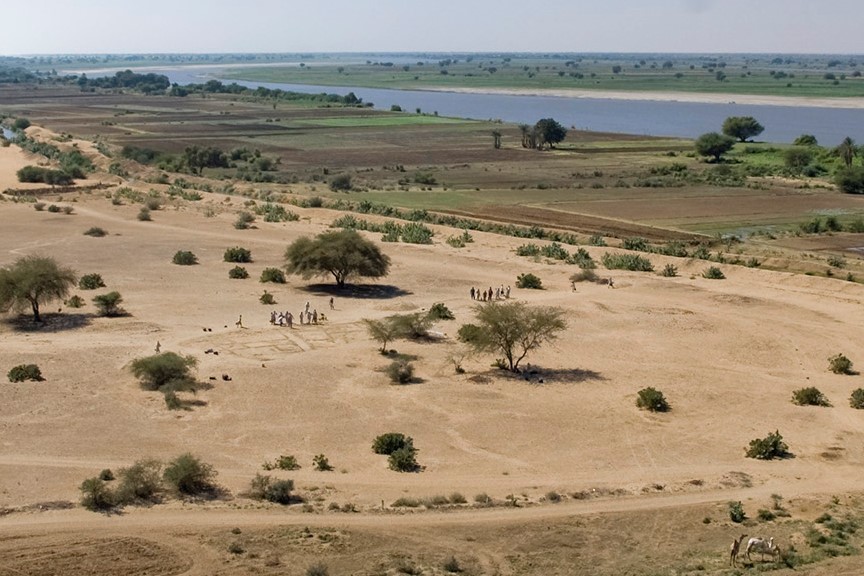
The settlement mound of Hamadab, of ca. 200 x 250 m size, is located in the riverine farmland, only few metres from the steep banks of the Nile. Nevertheless, rather than being an agricultural village, its urban community lived in a densely populated settlement with cramped housing blocks of mud brick, narrow streets and a high enclosure wall. Although Hamadab lies in the immediate vicinity of the capital Meroe, it comprises all important functional elements of a town: a temple and a public square, an administrative building, a public well and specialised production facilities for everyday consumer goods such as ceramic vessels, faience and iron objects. The residential quarters of Hamadab offer rich evidence of the living conditions in the Meroitic kingdom. Several households with kitchens and everyday utensils have been excavated here in recent years.
Since 2001 the team around Pawel Wolf has been investigating the buildings, the layout and the development of the town. In addition, a multidisciplinary survey in the surroundings of Meroe contributes to a better understanding of the wider settlement area, of ancient land use and the interrelationships of the people with their environment. The cooking pots, storage containers and hearths of the town are currently studied in detail by the Connecting Foodways project.
Members
Pawel Wolf
DAI Oriental Department
pawel.wolf@dainst.de
Ulrike Nowotnick
DAI Berlin Head Office
Ulrike.Nowotnick@dainst.de
Dr.-Ing. Catharine Hof
DAI Oriental Department
catharine.hof@dainst.de
Saskia Büchner-Matthews
saskia.buechner@yahoo.de
Partner organisations
National Corporation for Antiquities and Museums (NCAM)
Fig. 1 Hamadab is one of several Meroitic settlements aligned along the east bank of the river Nile [photo by Pawel Wolf].
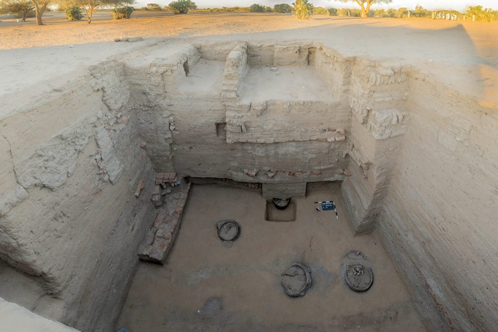
Fig. 2 The excavation trench in the main road cuts through four metres of occupation sequence [photo by Pawel Wolf].
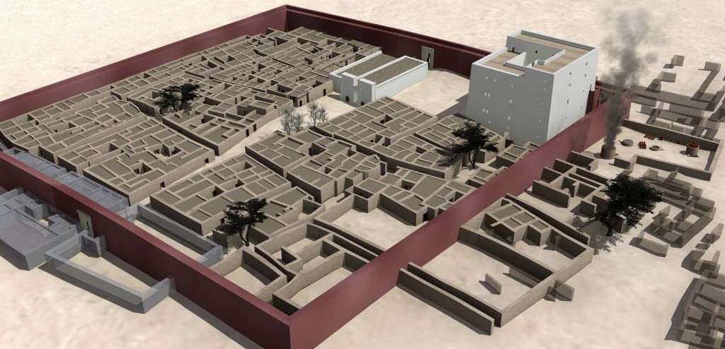
Fig. 3 Virtual reconstruction of the ancient townscape as indicated by the archaeological record [Figure by Catharine Hof].
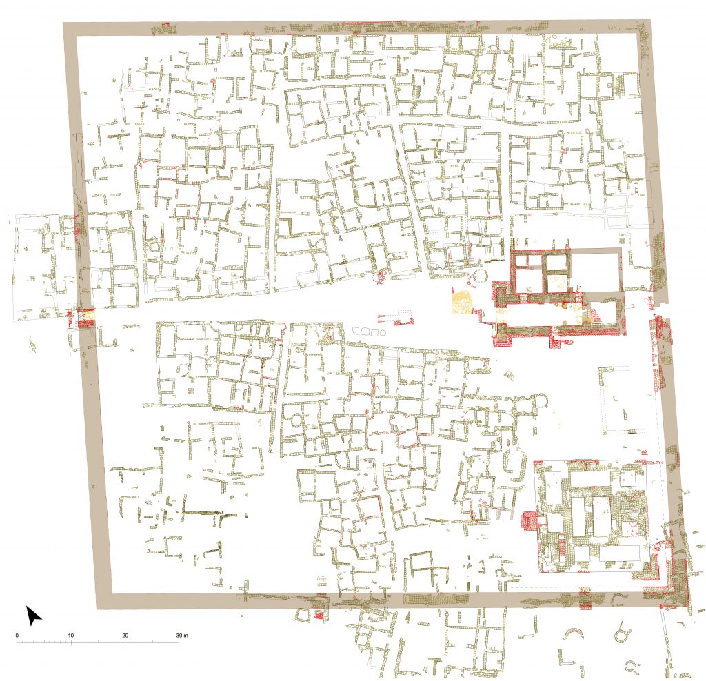
Fig. 4 Archaeological plan of the walled upper town of Hamadab (ca. 3rd century BC – 4th century AD) showing a planned layout with main road, temple, tower house and living quarters [Photo from the Hamadab Project].
This website uses cookies to improve your experience while you navigate through the website. Out of these, the cookies that are categorized as necessary are stored on your browser as they are essential for the working of basic functionalities of the website. We also use third-party cookies that help us analyze and understand how you use this website. These cookies will be stored in your browser only with your consent. You also have the option to opt-out of these cookies. But opting out of some of these cookies may affect your browsing experience.
Necessary cookies are absolutely essential for the website to function properly. This category only includes cookies that ensures basic functionalities and security features of the website. These cookies do not store any personal information.
Any cookies that may not be particularly necessary for the website to function and is used specifically to collect user personal data via analytics, ads, other embedded contents are termed as non-necessary cookies. It is mandatory to procure user consent prior to running these cookies on your website.