Previous geoarchaeological case studies in the Pergamon Micro-Region have indicated not only the environmental potential for human activities, but also changing Holocene morphodynamics in the western lower Bakırçay plain and the adjacent piedmonts due to both natural processes and human activities Large spatial-scale geological studies in western Anatolia suggest a complex tectonic-dominated landscape of uplands (horsts) and plains (grabens) in the Bakırçay and Madra River Catchments. In order to further reconstruct the geomorphodynamics and get insight to the suitability for various human activities and human influence of the landscape, an identification of geomorphological characteristics of the catchments of the Bakırçay and Madra rivers is essential.
We used multiple materials and methods, including geomorphometric analyses of a digital elevation model and visual interpretations of satellite images, to describe the landform features of four different geomorphological units in the Pergamon Micro-Region.
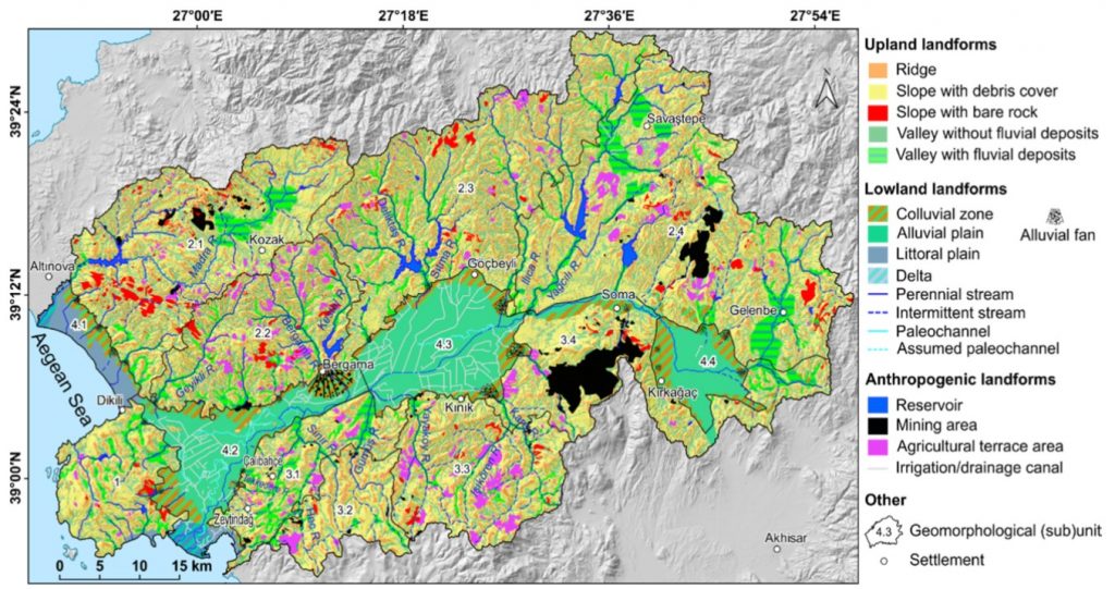
In our recent study, we show that asymmetries in relief, drainage network, and sediment accumulation exists between the Kozak Mountains north and the Yunt Dağı Mountains south of the lower Bakırçay plain (Figure 1). The remarkable asymmetries are dominantly shaped by tectonics that formed a horst-and-graben structure and fault-related geomorphological features. Ancient settlements in the micro-region, mostly found on the piedmonts, are likely considered the landscape factors of flood protection, through traffic, and easy access to different natural resources, such as stone, mineral, water, and wood. As a consequence of intensive settlement activities, landscape engineering measures during the last centuries were implemented simultaneously with a parallel change in morphodynamics.
Our study comprehends the geomorphological characteristics and their potential developing processes of the Pergamon Micro-Region and further provide a basis for the analysis of human activities in different environmental settings.
Original publication:
X. Yang, F. Becker, D. Knitter, B. Schütt – An Overview of the Geomorphological Characteristics of the Pergamon Micro-Region (Bakırçay and Madra River Catchments, Aegean Region, West Turkey). Land 2021, 10(7), 667
The paper is available here: Full Text | PDF Download