by Felix Pirson, Bernhard Ludwig, Güler Ateş
In antiquity, people’s relationship with nature was strongly influenced by religion. Natural phenomena such as thunder and lightning, but also the dawn or the ripening of crops were associated with the intervention of divine powers. People turned to them for blessings or protection from harm by the forces of nature, which were perceived as omnipotent.
The numerous natural shrines that have survived in the ancient Mediterranean world and beyond are an expression of this religious attachment to nature. Unlike the large official sanctuaries with their elaborate architecture, imagery and inscriptions, they consist primarily of a natural feature such as a prominent rock or mountain peak, a spring, a cave or even a grove, which is venerated as the dwelling place or manifestation of the deity. Often several natural phenomena, especially rock and spring, may also be combined. In most cases, rock carvings in the form of niches, benches, footings for altars or gutters and basins for water installations bear witness to the cult sites. In addition, concentrations of votive offerings made of clay, i.e. small images of gods, oil lamps or pottery for festive meals as part of the cult, are important indicators of the presence of a natural sanctuary.
Four rock or natural sanctuaries were previously known in the Pergamon Micro-Region (Fig. 1), of which the particularly significant cave sanctuary ‘Ballık Mağarası‘ was only discovered in 2020 as part of the TransPergMikro. However, several rock sanctuaries could also be detected within the fortified urban area of Pergamon, too. Rock sanctuaries within and outside the city have numerous similarities, but also significant differences, which characterise them all as very individual, site-specific creations with a direct connection to nature and the landscape. One of the common features of the majority of the cult sites is that they have visual references to each other and are oriented towards the sanctuary of Mamurt Kale in the mountains southeast of Pergamon, which was monumentally expanded under the founder of the Attalid dynasty Philetairos (281-263 BCE). In this sanctuary, the mother goddess Meter, originally from central Anatolian Phrygia, was worshipped. Her powers lay in the areas of nature and fertility. She was also exceptionally popular in Pergamon, where we encounter her, among other things, in the form of a life-size statue on the terrace of the Great Altar. Most of the rock sanctuaries known so far in the Pergamon Micro-Region, all located in the lower western plain of the Bakır Çay (Kaikos), were dedicated to her. According to the current state of research, we can thus assume that Meter played an essential role in the interaction between humans and nature in the Pergamene landscape, which was further promoted by the Attalid dynasty and also used to legitimise their rule in the core area of their territory.
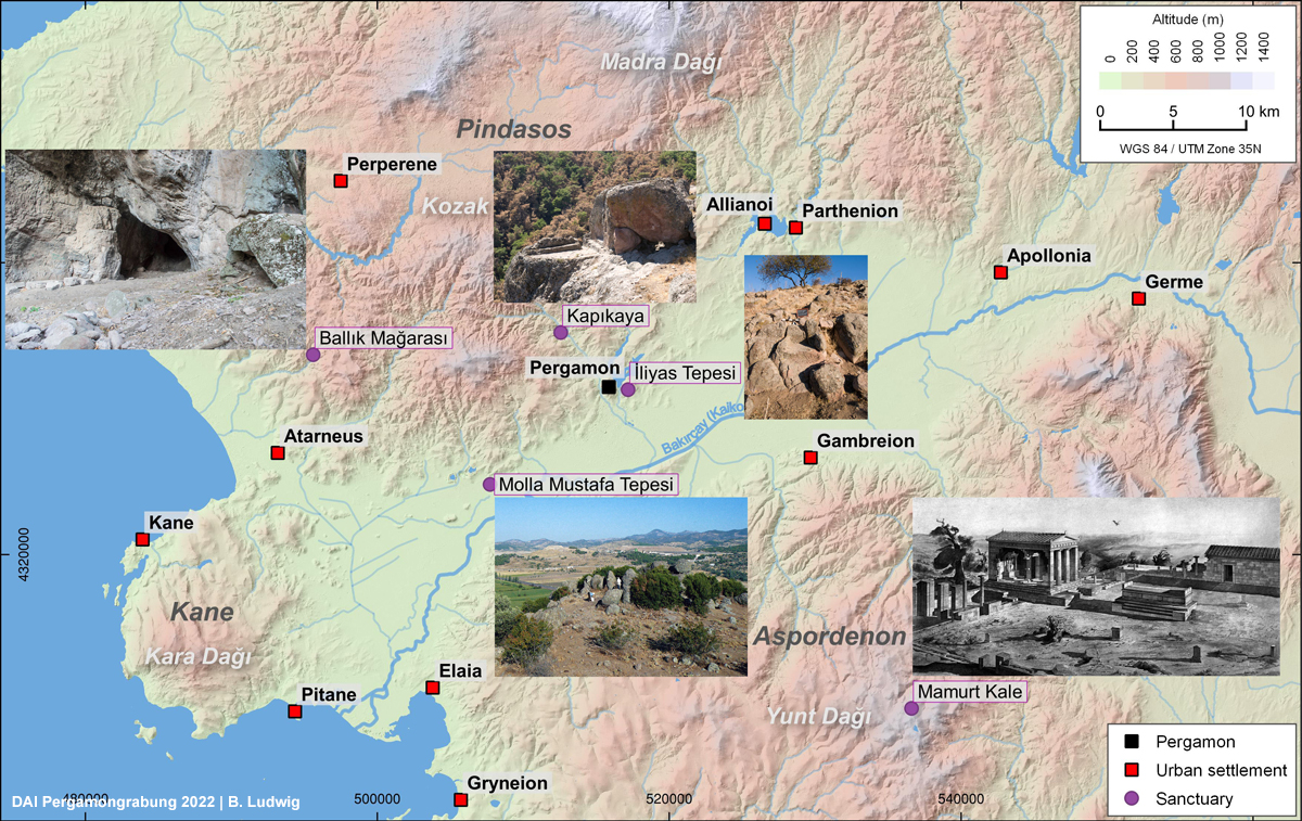
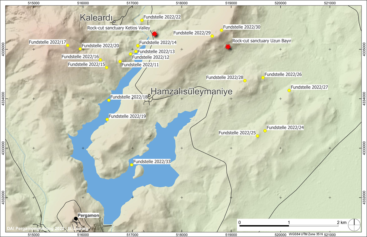
Fig. 2 (right) Umlandsurvey 2022. Location of new rock sanctuaries and other new sites
Against this background, we were very curious to see whether this year’s archaeological survey, which was extended for the first time into the landscape up to about five kilometres northeast of Pergamon (Fig. 2), would yield further natural sanctuaries and indications of the cult of Meter. Our expectations in this regard were not disappointed: in the lower valley of the Kestel Çayı (Ketios), a particularly prominent rock formation caught our eye (Fig. 3). From there one can enjoy an outstanding view over the entire valley and at the same time the rock formation is a prominent landmark (Fig. 4). High up in the formation we discovered a niche with two dowel holes in its floor, which most likely served to fix a statue with an elongated rectangular cross-section (Fig. 5). A GIS-based viewshed analysis, which reveals which areas were visible from the niche (Fig. 6), underlines the prominent position of the niche in relation to the lower reaches of the Ketios, where, in addition to a fortified settlement of Classical times on Çoban Tepe, there were also several Hellenistic-Roman farmsteads and hamlets. At the same time, it becomes clear that the self-contained character of the settlement chamber also limited the field of vision of the niche.
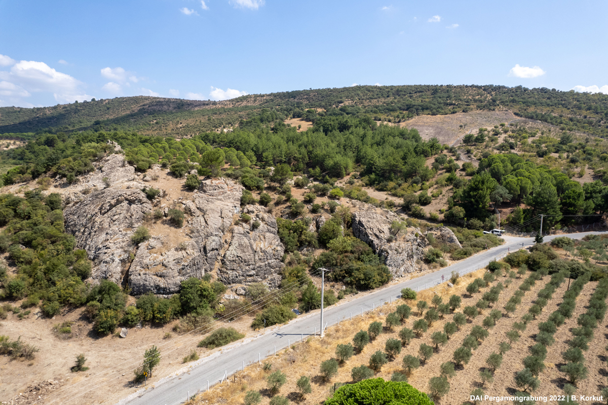
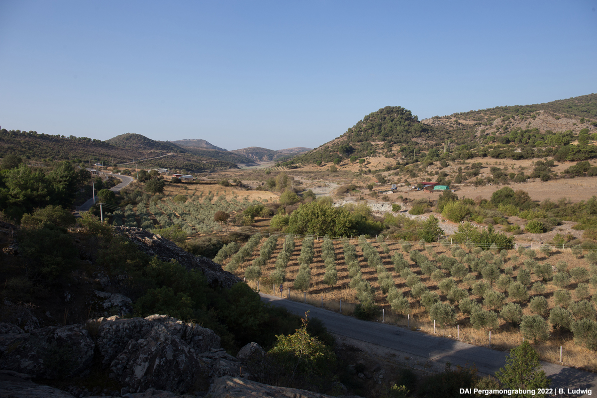
Fig. 4 (right) Ketios Valley. View from the niche into the river valley and to Pergamon
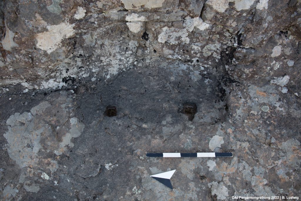
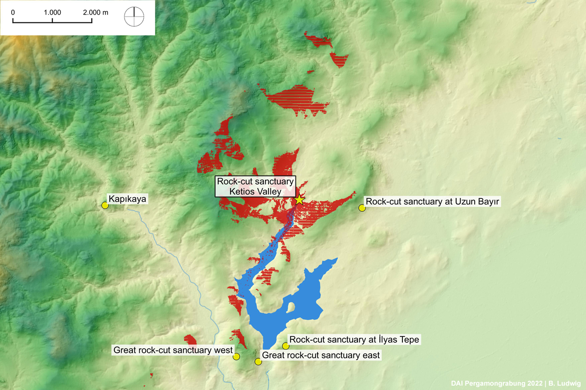
Fig. 6 (right) Ketios Valley. Viewshed of the niche. Areas indicated in red are visible from the niche
Since no artefacts were found on the surface of the rock around the niche, its attribution to a specific deity and its dating cannot be determined easily. At the foot of the rock there is a spring that is still flowing today. In any case, the combination of prominent rock formation, spring and niche for an image with an elongated rectangular cross-section (figure on throne or in naiskos?) corresponds entirely to the picture we have gained so far of the appearance of the shrines of Meter in the Pergamon Micro-Region.
A second site was discovered only in the last days of the survey on the eastern slope of the elongated hill of Uzun Bayır, which, together with the nearby Taş Tepe, formed the narrow entrance to an extensive fertile plateau to the north-east of Pergamon (Fig. 2). Both hills were exploited on a large scale as quarries in antiquity and must have played a key role in supplying Pergamon with the volcanic andesite. The cult site was established in a conspicuous, tapering rock formation, which can be seen from afar (Fig. 7). At the foot of the rock is a spring that has only recently been architecturally rearranged. In this process, a new terrace was created, whereby any finds that may have been present here were relocated or covered over and is therefore inaccessible to us. Indications for a use as a sanctuary are again a rock niche (Fig. 8) as well as a major reworking of the rock in the area of the spring: the floor and rock face have been smoothed and thus stand out strikingly against the natural rock surface. On the wall, the smoothed surface is framed by two rectangular niches or recesses for the attachment of small picture panels or reliefs (Fig. 9). The artificial modifications of the rock are in turn very directly reminiscent of securely identified rock sanctuaries in the Pergamon Micro-Region and thus form the basis for the interpretation of this site as a simple rural sanctuary of Meter as well.
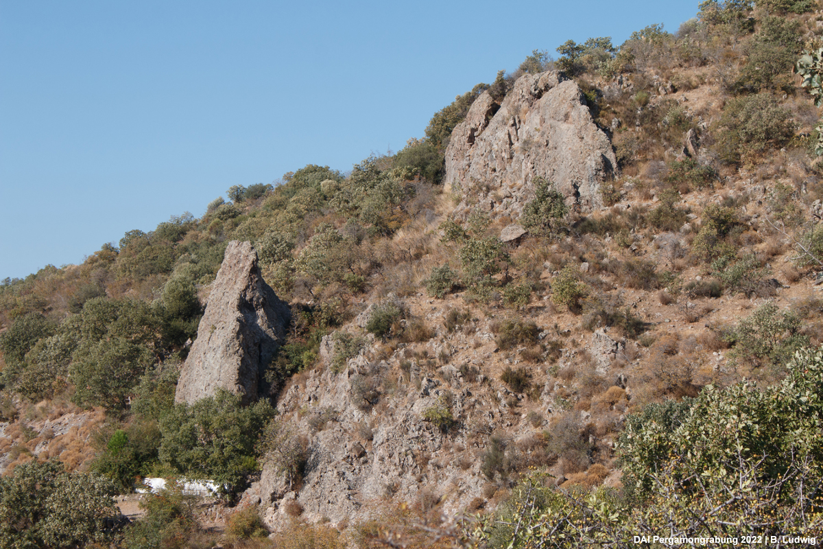
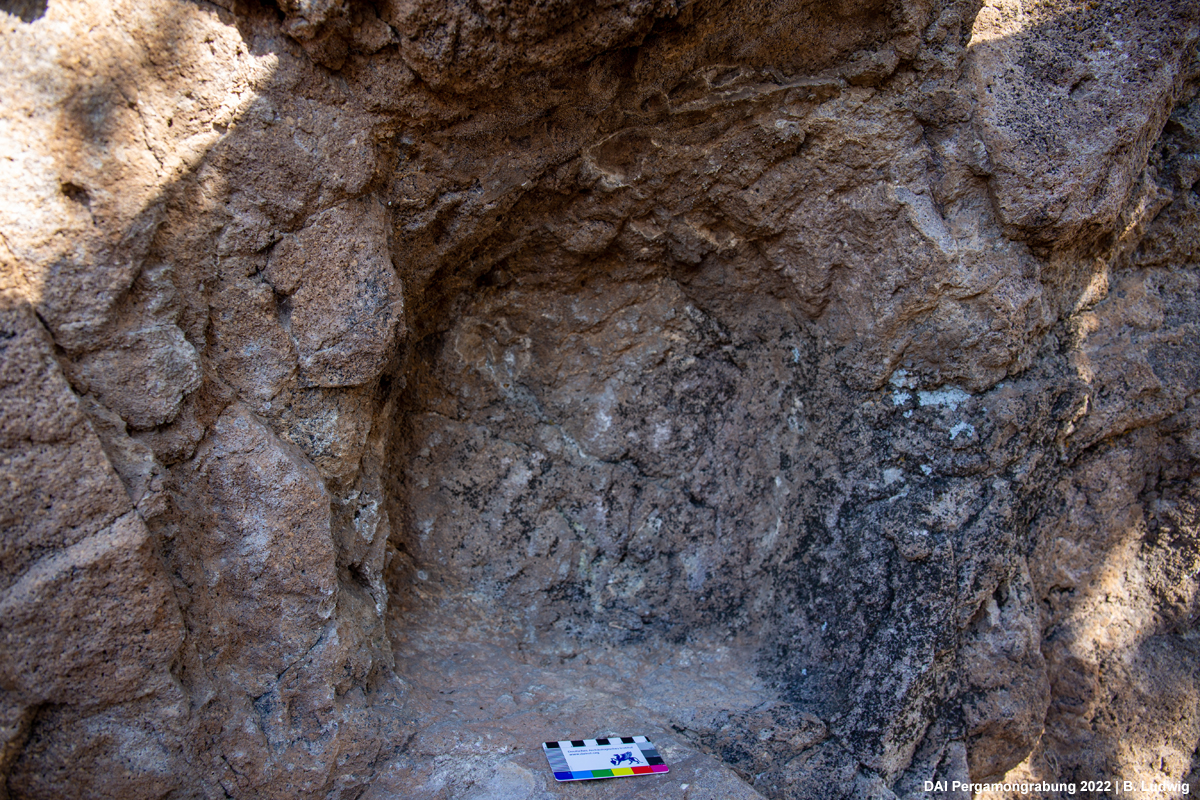
Fig. 8 (right) Rock-cut niche
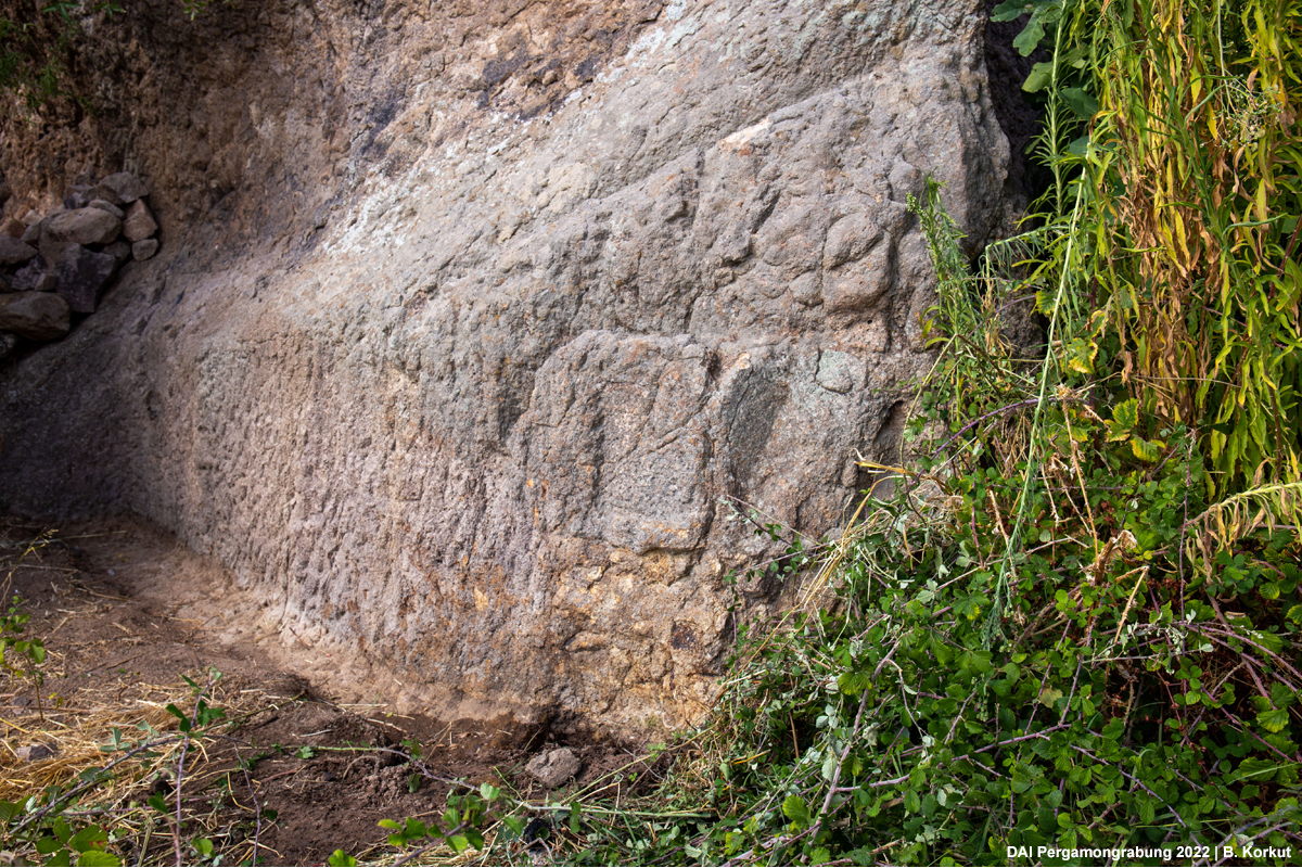
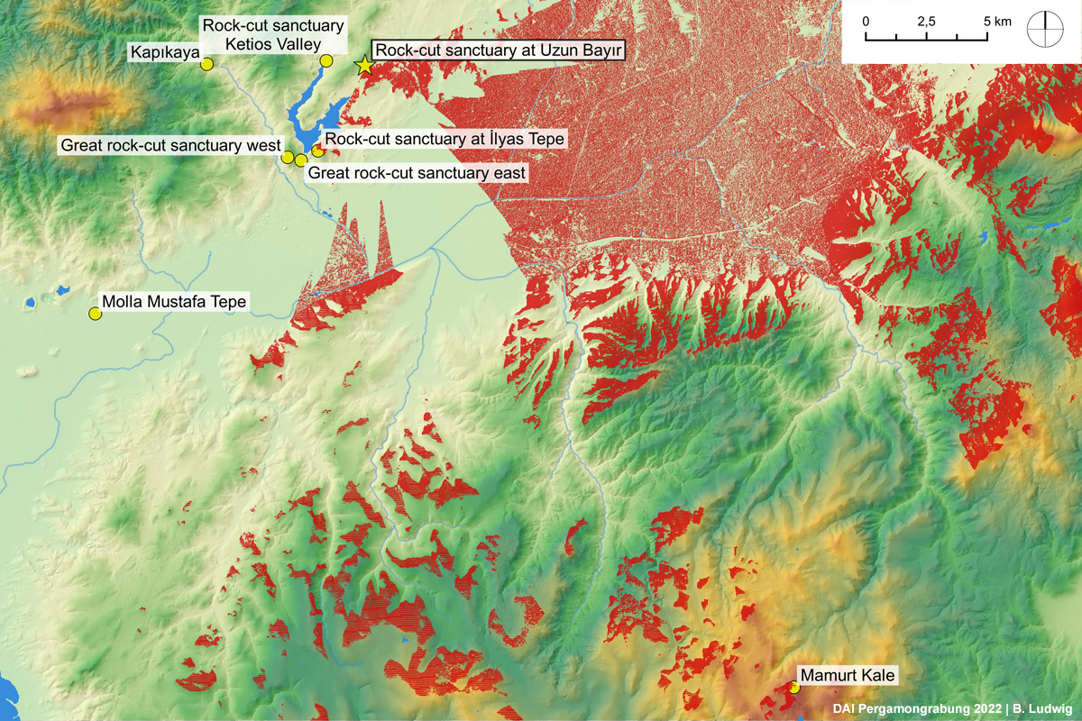
Fig. 10 (right) Uzun Bayır. Viewshed of the niche. Areas indicated in red are visible from the sanctuary
The viewshed (Fig. 10) of the site on the eastern slope of Uzun Bayır makes clear how, thanks to the specific topographical situation, a much more extensive field of vision was achieved, which now also includes the Meter sanctuary of Mamurt Kale and İlyas Tepe, on which another rock sanctuary was located. Thus, the cult site on the slope of Uzun Bayır is fully integrated, both in its orientation towards Mamurt Kale and with regard to individual visual relations, into the visual network between the various Meter and natural sanctuaries that we have so far been able to identify in the western half of the lower Kaikos plain (Fig. 11). The sanctuary on the eastern edge of the lower Ketios valley, on the other hand, seems isolated in the context of the network.
From this, the following, still hypothetical conclusions can be drawn, which would have to be verified in the coming years: The visual region of Pergamon extended to the eastern lower Kaikos plain, even if the visual impact of the metropolis, whose city prospect was oriented entirely to the southwest (Fig. 12), may have been less dominant here. For the construction of the rock sanctuaries, the relationship to the local topography and the covering of a local visual/visibility field were of primary importance. This certainly applies to the shrine in the lower valley of the Ketios, but also the cult site on the eastern slope of the Uzun Bayır relates primarily to the fertile plateau northeast of Pergamon (Fig. 13). This confirms our previous picture of the rock sanctuaries as local religious manifestations in the interaction of humans and nature. The integration of the cult site at Uzun Bayır into the network of natural and Meter shrines, and thus also into the visual region of Pergamon, also opened up numerous other options of perception and interpretation for visitors to the shrine, which cannot be discussed in detail here. The reference to Pergamon played a role in this context on various levels, including the special promotion of the regional Meter cult by the Attalids. If one considers that the fertile basin to the east of the Uzun Bayır was not only important for the supply of agricultural products to Pergamon, but that a large part of the stone material used in the metropolis also came from there, it becomes particularly understandable why one wanted such an important landscape to be under the beneficial gaze of the Great Mother (Meter).
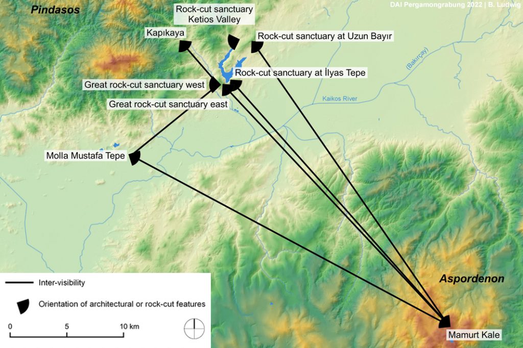
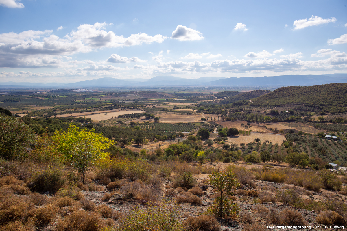
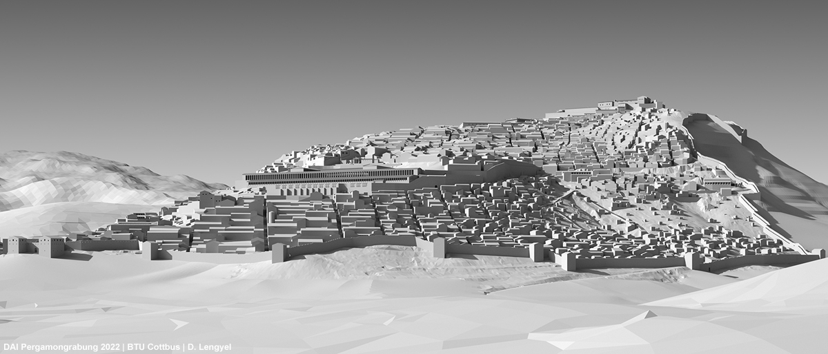
Fig. 12 (bottom) Pergamon. Reconstruction of the city prospect of Pergamon from southeast
Fig. 13 (top right) Uzun Bayır. View from the rock sanctuary into the plain
Further reading:
Ateş, G., „Pergamon´da Doğa ve Kült: Ana Tanrıça İnancı ve Doğal Kutsal Alanlar. Nature and Cult in Pergamon: Meter Worship and Natural Sanctuaries,“ in Pergamon. Anadolu´da Hellenistik bir Başkanet. A Hellenistic Capital in Anatolia, edited by F. Pirson and A. Scholl, pp. 422-435. Istanbul: Yapı Kredi Yayınları
Pirson, F., 2017 „Die Siedlungsgeschichte Pergamons – Überblick und kritische Revison. Mit einem Appendix von Anneke Keweloh-Kaletta,“ Istanbuler Mitteilungen 67: 43-130 (in particular pp. 61-62. 92-95)
Pirson, F. and Ateş G., “Wasser als (natürliches?) Element in den Naturheiligtümern am Stadtberg von Pergamon,” in Natur und Kult in Anatolien, edited by B. Engels, S. Huy., and Ch. Steitler, pp. 59-90. Istanbul: Ege Yayınları.
Pirson, F. and Ateş, “Meter in the Pergamon Micro-region: Formation, Functions, and Transformation”, in N. Lovejoy, L. D´Alfonso, et al. (eds.) Phrygia between East and West. Ancient Near Eastern Studies (in print)
Pirson, F. and Ludwig, B., “Tumuli and Natural Sanctuaries: Visual Aspects of Urban Space- and Landscape-Interaction in Hellenistic Pergamon and its Micro-region,” in Sacred Lands, Connecting Routes. Religious Topographies in the Graeco-Roman World, edited by C. G. Williamson. Leiden: Brill (in print)