by Fabian Becker, Bernhard Ludwig, Léa Geisler, Yannic Grohmann, Ulrich Mania, Ida Rewicki, Ihsan Yeneroğlu
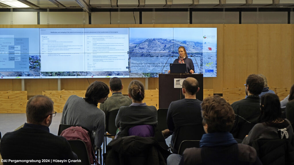
In Pergamon, the Selinos River (today’s Bergama Çayı) emerges as a central element shaping the city’s urban physiognomy, more than its counterpart, the Ketios River (today’s Kestel Çayı). Despite this significance, the Selinos often played a peripheral role in the narrative of settlement history and urban development in past research. In the course of the TransPergMicro project the river receives increased attention. It is now an integral component of our understanding of the interaction between human activities and the natural environment in Pergamon, including e.g. the impacts of construction activities on the river dynamics. This was most recently underlined at the annual TransPergMicro workshop on »Modification and reshaping of the natural environment as a dynamic phenomenon in the transformation of micro-regions«, which was held at the Technical University Berlin on January 12‒13. The Selinos River was the focus of a session on »Urban development and the alteration of natural space: Impact on rivers« (Fig. 1).
The sessions centered on presentations that showcased the results and ongoing research of master’s and doctoral theses examining an ancient enclosure along the Selinos and the topography of the amphitheater, respectively. These talks were complemented by a contribution on the substructure of the ›Red Hall complex‹ and framed by presentations on the archaeological landscape and the geomorphology of the entire river and its alluvial fan. The subsequent discussion also benefited from the input of the ERC-granted STRADA project represented by Max Fiederling (Universität Trier) on the simulation of land and water-based transportation between the Adriatic Sea and the Danube.
The outcomes of this workshop will be incorporated into our interdisciplinary sub-project within TransPergMicro, focusing on landscape design and urban development, where we employ the Selinos River as a case study to investigate the relationships between urban development, the alteration of the natural environment and the resulting consequences.
In the following sections, we aim to outline key aspects of the various presentations and to discuss preliminary interpretations.
The Selinos and its catchment
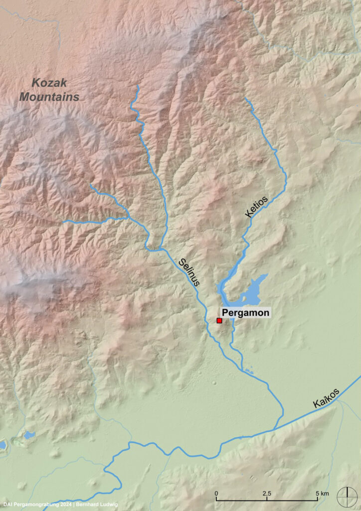
The headwaters of the Selinos are located in the Kozak mountains, reaching altitudes above 1000 m asl. The watershed borders the Kozak Plateau (Fig. 2). Due to its natural resources such as wood, metal and stone, this area was very likely of great importance for the supply of Pergamon. Accordingly, the Selinos valley and the eponymous river served as a major connection link between the Kozak region and the city of Pergamon. Additionally, water pipelines supplying the city and an important transportation route ran through the valley and along the river.
After resembling a typical mountain river, the Selinos valley floor widens as it enters a partly unconfined valley, currently utilized for agriculture and historically employed for corn milling. Remains of the milling infrastructure are still visible today. Shortly before reaching the modern city boundary, the Selinos flows into a narrow, confined valley with partly steep riverbanks before reaching its alluvial fan. This is where the modern city of Bergama and the remains of the Roman lower city of Pergamon are located. After a course of 21 km, the Selinos joins the Bakırçay river, becoming one of its main tributaries.
At the latest since the 1950s, modern engineering measures significantly altered the channel of the lower Selinos. Much of the Selinos’ water is currently diverted north of the city into the Kestel reservoir in the neighboring river catchment. The natural course of the Kestel River in return is diverted into the Selinos river southeast of the city. Both measures apparently changed the discharge of the river. In recent years, the banks of the Selinos have been reinforced with stone walls. On the alluvial fan, the channel was in addition straightened, deepened and widened.
Urban Development and the Alteration of Natural Space
During the Hellenistic period, most settlement activities in Pergamon took place on the city hill. In the following centuries, especially from the 1st century CE, the city’s urban area expanded. The focus of construction activities spread from the hill down to the alluvial fan. One of the most remarkable buildings from this period was the ›Red Hall‹, whose ruins still characterize the appearance of modern Bergama today. Besides its cultural significance, the ›Red Hall‹ is also a remarkable piece of Roman river engineering as the building complex was constructed above the river. For this purpose, the natural riverbed was built over with two parallel barrel vaults made of mortar masonry and a length of over 180 m (Figs. 3-4). To this day, the Selinos river flows through these culverts, whose floor is also paved with massive andesite blocks. Investigations also showed, that the upstream openings of the culverts were equipped with installations in order to control the flow and protect the construction from structural damage by the current of the stream.
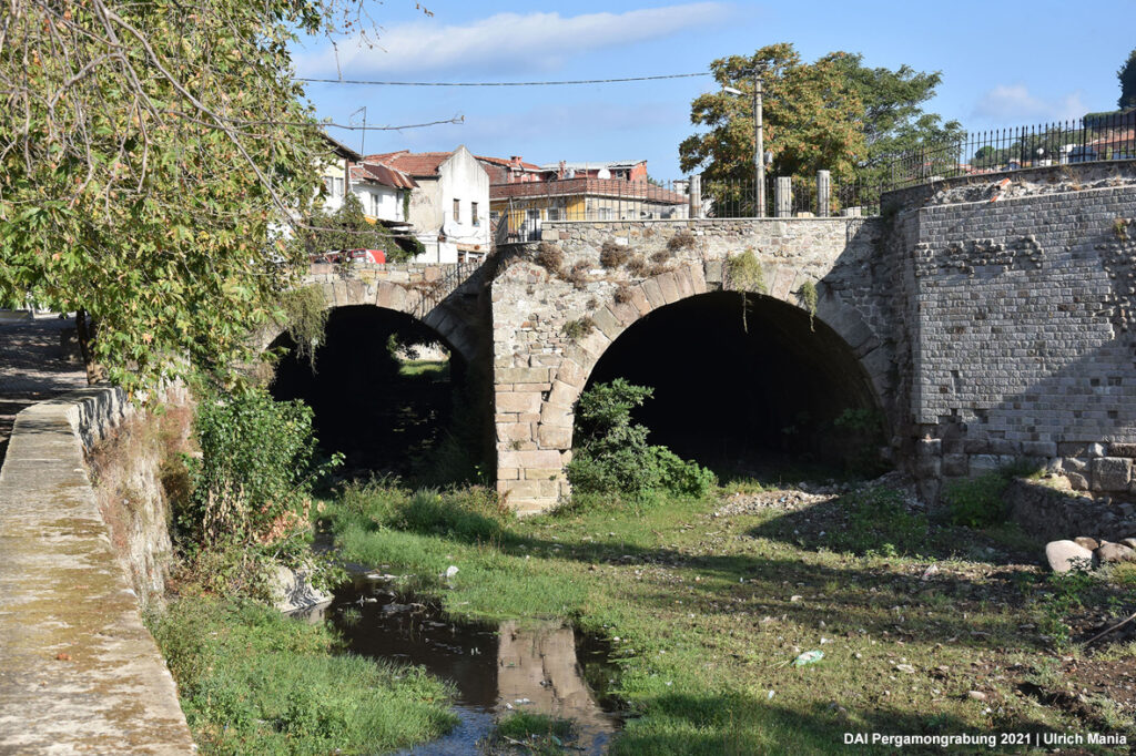
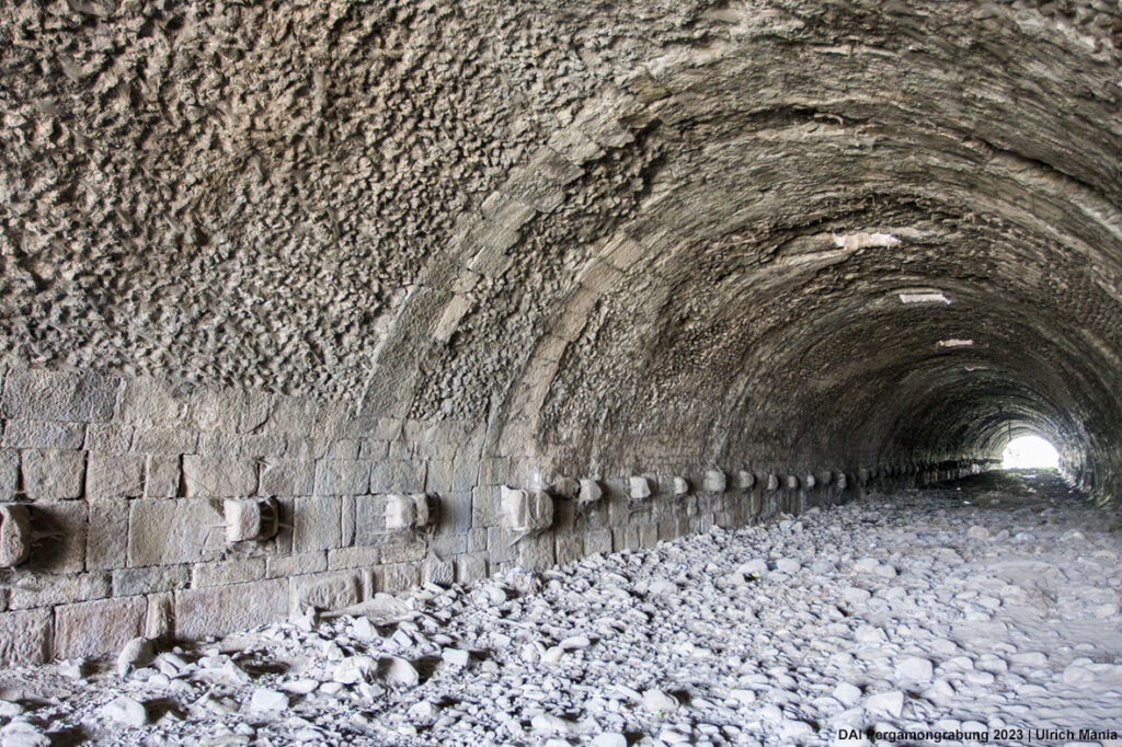
Fig. 4 (right) Culvert of the ›Red Hall‹
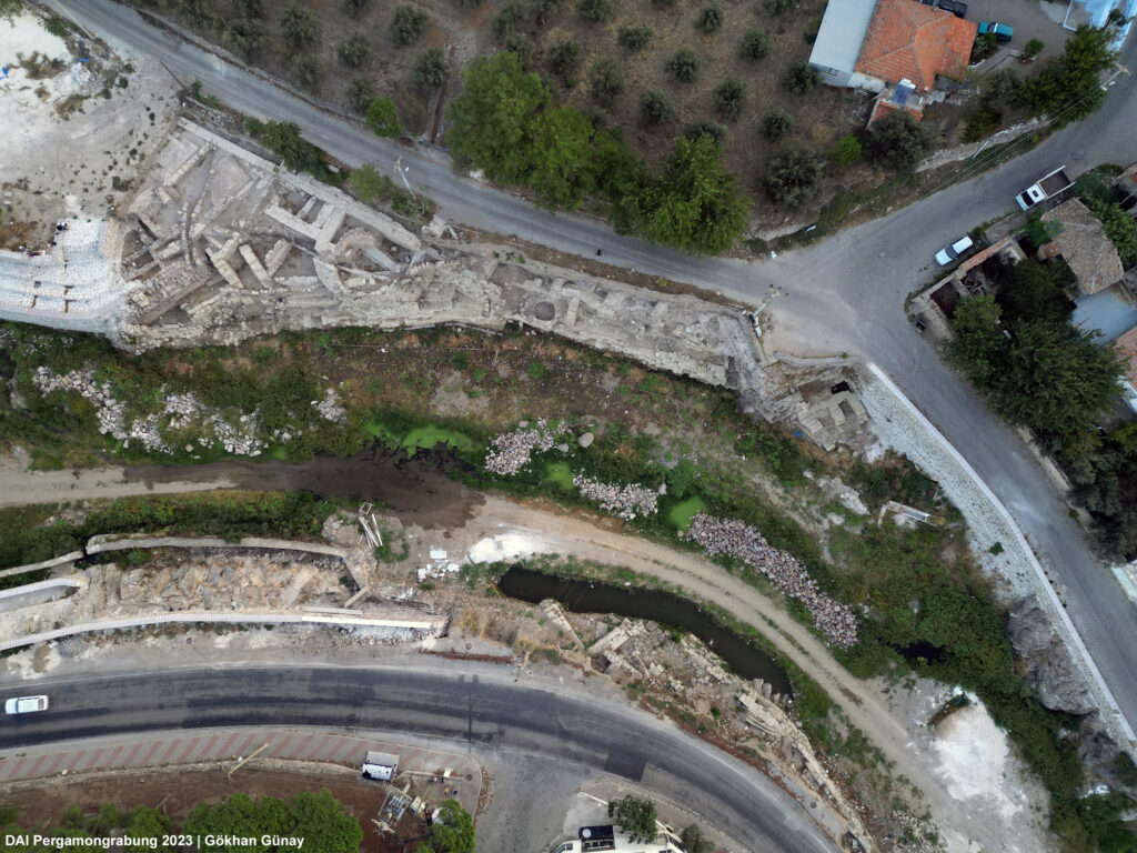
Further ancient constructions, which were realized during the urban development and changed the natural space of the Selinos, are situated a few hundred meters upstream of the ›Red Hall‹. Here, a part of the urban river enclosure (Fig. 5) was recently excavated by the Bergama Museum and studied by the Department of Historical Building Research and Monument Preservation at the Technical University of Berlin as part of TransPergMicro. It is located on a cutbank of the Selinos which consists mainly of slope debris, in contrast to the more stable bed rock banks nearby. The ancient structures include the remains of an artificial river enclosure directly on the present-day riverbed, as well as representative structures. Both appear to date from the Roman Imperial period. Remains of artisan activities date to a later construction phase. The complex also includes water-bearing structures such as covered channels, gutters and probably a pipeline.
Close to the ancient riverbank, a Late Hellenistic bridge (Kazancı Köprüsü) was located (Fig. 6). The bridge originally had three arches, one of which was closed in the Roman Imperial period during the construction of the river enclosure. Both the closing of the bridge’s arch and the construction of the riverbank enclosure had a notable impact on the Selinos River. The flow velocity of the Selinos was increased particularly by the steepening of the banks and the narrowing of the river cross-section. A presumably Roman weir between these buildings and the ›Red Hall‹ also had an influence on the water flow.
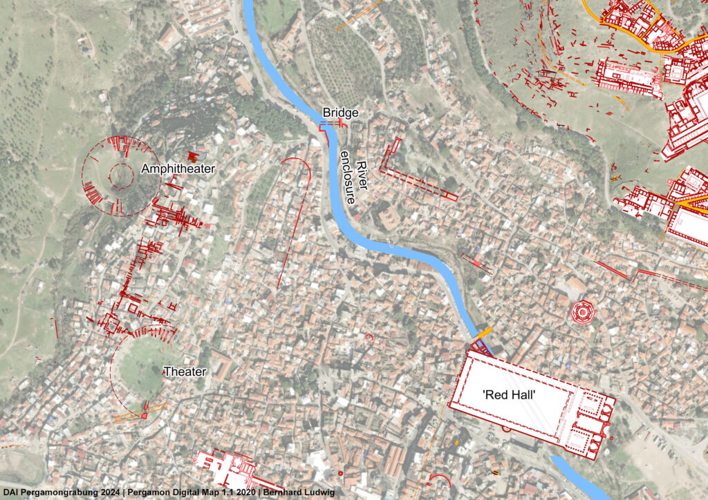
A third feature that alters the natural space and the natural course of the river in Pergamon’s urban area is the amphitheater, which also dates back to the Roman Imperial period. Taking advantage of the topography, it was built in the valley of a tributary of the Selinos, about 300 m above the confluence with the main river. Parts of the amphitheater’s substructures were therefore built directly on the slopes of the valley west of the Musalla Mezarlığı hill. Current research as part of TransPergMicro has revealed many new insights into this monumental building. By incorporating and altering the natural environment at this location, a number of special characteristics were created. The creek, for example, was led through an artificial channel below the building, which follows the natural relief (Fig. 07-08). This is reminiscent of the culverts under the ›Red Hall‹. The entrances to the arena were also not on opposite sides, as one would expect. Using the amphitheater as an example, various aspects regarding the use of natural space and resources were discussed, in particular the assumption that the choice of a valley as a construction site for the amphitheater saved resources, but created significantly higher construction costs and a higher degree of planning. Furthermore, a scenario was discussed in which water could be led into the arena through a canal and drained again via the stream below. This suggests that the Amphitheater was used for naumachiae, small-scale naval combat shows. In addition to the integration of the monumental building into the natural landscape on Musalla Mezarlığı hill and its influence on the tributary of the Selinos, the amphitheater also contributed to the overall urban development of Pergamon.
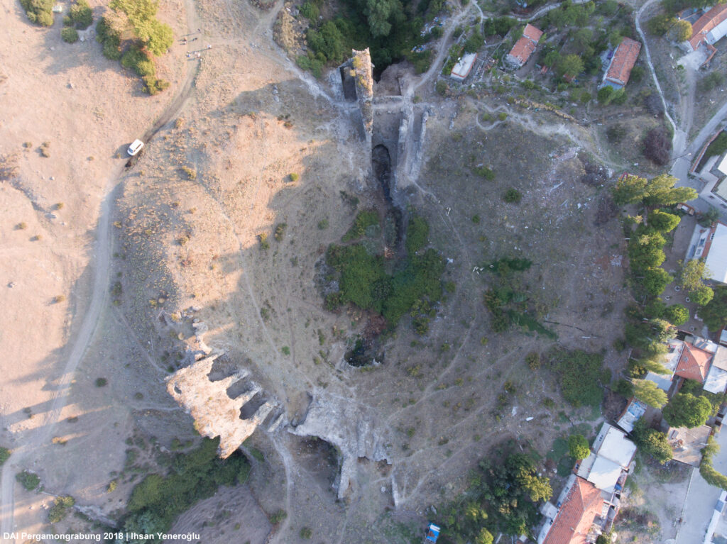
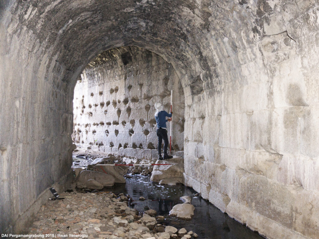
Fig. 8 (right) Surveying work on the stream that flows under the amphitheater
Changing river dynamics
The different observations of how the Romans shaped the natural course of the Selinos in the urban area of Pergamon inspired an interdisciplinary group from TransPergMicro to investigate the changing flow characteristics in more detail. Recent calculations gave first insights into the impact of the ›Red Hall’s‹ culverts and the upstream weir, in particular the resulting change in gradient and the narrowing of the channel. Based on newly acquired airborne LIDAR elevation data, Structure from Motion data, and the architectural survey of the ›Red Hall‹, the channel gradient was reconstructed. Using this data and the Manning-Strickler formula, it was possible to show more precisely than in earlier calculations that the culverts of the ›Red Hall‹ have a sufficiently high capacity – even to divert discharges from rare flood events. Furthermore, the increase of the flow velocity in the culverts reduced erosion of the pavement by simultaneously having enough transport capacity to reduce sedimentation. Regarding the river enclosures, the calculations show that its walls were presumably high enough to prevent its terraces from regular flooding.
Geomorphological observations in the confined valley above its apex and on the alluvial fan also indicate that the areas where the Roman lower city was located, including the above-mentioned structures, were protected from flooding. Sedimentological findings from the alluvial fan of the Selinos southeast of Pergamon showed that deposition of sediments related to floods took place (mainly) in downstream areas outside urban area. Here, several meters of overbank fines were deposited. This is supported by old maps published in the late 19th and early 20th century by Otto Belet and Alfred Philipson. These maps, as well as the analysis of longitudinal profiles of the Selinos river, show a braided-like channel structure downstream of the ancient city, which also indicates flooding and deposition there.
In this area, 2 km south-east of the city, the archaeological survey found a large estate or farmstead from the late Hellenistic-early Roman period. When it was documented in 2020 as part of the archaeological survey, it became apparent that the rooms, some of which were still up to 4 m high, were completely filled with alluvial fines (Figs. 09-10). The Physical Geography group in TransPergMicro, in cooperation with Mehmet Doğan and students from Ege University Izmir, documented sediments from various outcrops in the gravel pit. The chronology of the sediment sequences shows a clear increase of morphodynamics in the Roman Imperial period, especially between the 2nd and the 4th century, thus probably after the above-mentioned structures along the river had been built.
The anthropogenic changes to the natural environment within the ancient city could have led to the end of such estates or farmsteads in the immediate vicinity of Pergamon, or at least accelerated the respective processes. Similar connections between the creation of new habitats and the simultaneous anticipation of the destruction of their own livelihoods have been observed in the city of Elaia, where the siltation of the harbor can be related to intensified agriculture activities in the chora of the city.
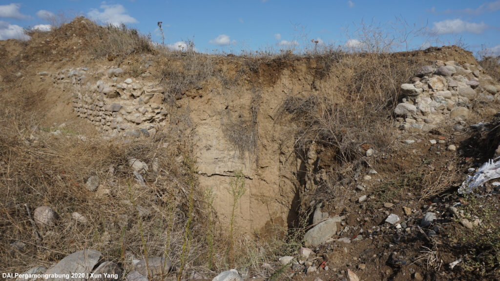
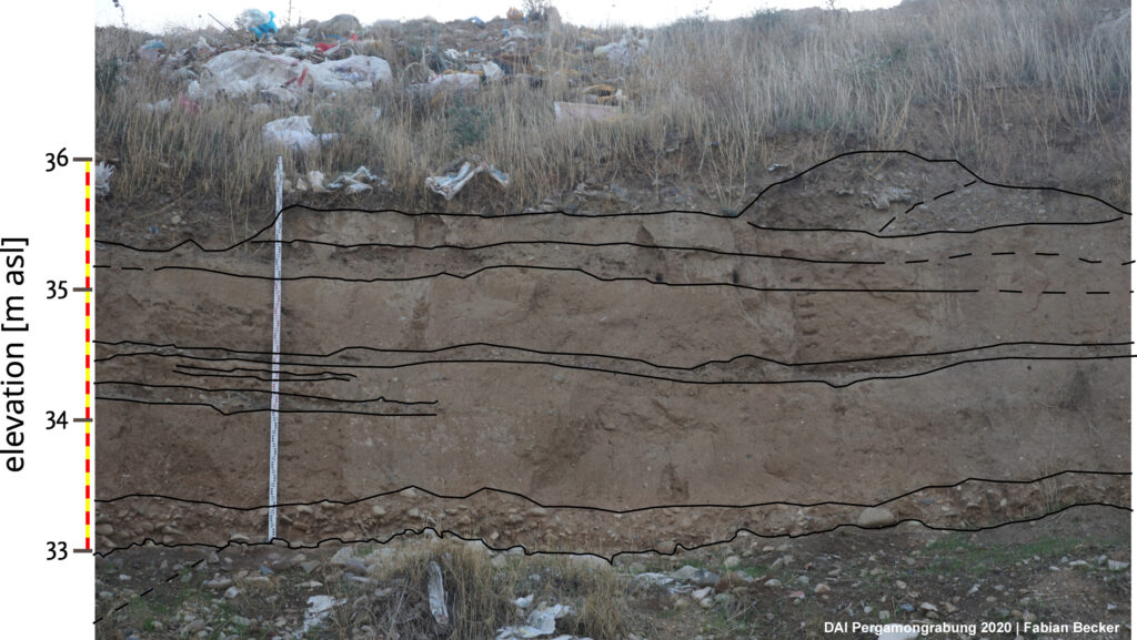
Fig. 10 (right) Exposed sediment profile in suburban Pergamon, showing the fine sediments interlayered by gravel layers containing abundant ceramics
Conclusions
The collaborative examination and discussion of the relations between urban development, the alteration of the natural space and changing river dynamics using the example of the Selinos already provides new insights at the current stage. By combining the results of archaeological, architectural and geoarchaeological investigations, it becomes evident that the expansion of the Roman lower city along the Selinos and its alluvial fan was accompanied by a remarkable transformation of the banks and the riverbed. The resulting change in river dynamics can be seen in the increased sedimentation of the alluvial fan and in archaeological sites in the south-eastern periphery.
In the ongoing research we will further process the available data and refine the calculations. In the course of the recent workshop at TUB, several interpretations of the whole setting have been discussed and will be further discussed. The focus on this discussion is on the question whether the various measures during the Roman Period were mainly guided by the efficient utilization of limited space for urban development, flood prevention, the economic valorization of the Selinos (and its tributary), or not the least bit by a mindset of natural domination of nature that developed in Roman times.