Zeki Mete Aksan & Bernhard Ludwig
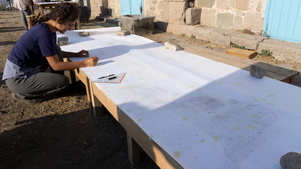
A day in the survey, a week and a month …
They pass so fast but seem like a lifetime.
The roads to take, rivers to cross, valleys to roam …
And so many hills, you climb up and down.
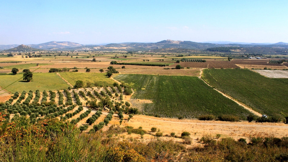
In a survey, a site is sometimes visited more than once. These visits may be in the same season or in different ones. Sometimes the fields are planted with corn and cotton. Sometimes pomegranate gardens cover a portion of the site, not giving any passage to the survey team and thus preventing archaeological documentation. One keeps looking at the surface of the soil from the edges of the fields. Pottery sherds and tiles lie there, waiting to be seen, counted, collected and sometimes put into small bags. Olive gardens are favorable, especially those that have been ploughed and well maintained, because the possibility of finding something meaningful is high. Or sometimes you just have to wait for the right time, after the harvest is removed and the fields are ploughed.
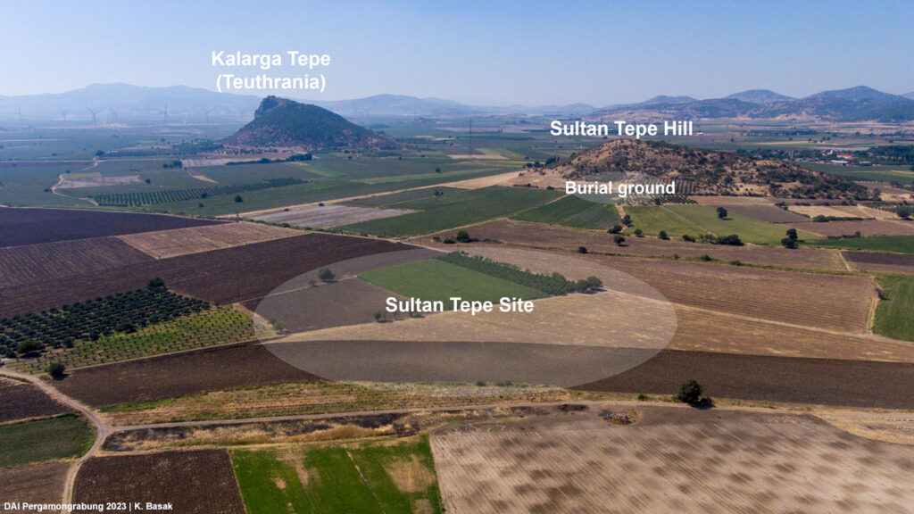
The site near Sultan Tepe was just such a place. It was first discovered in 2009 and surveyed in 2011. Further research including archaeological survey, geophysical prospections and geographical analysis within the scope of TransPergMicro was executed in 2019 and 2020, nearly a decade after its discovery. It was among many other rural sites that were encountered and re-visited as part of the TransPergMicro project in the hinterland of Pergamon. Latest evidence combined with the results of previous surveys provided significant data and enabled us to make reliable interpretations of the site – even without archaeological excavations.
The site, named after the nearest natural hill, Sultan Tepe, lies southwest of Pergamon and in close proximity to the archaeological sites Kalarga Tepe (ancient Teuthrania) and Eğrigöl Tepe (probably ancient Halisarna). Its location is also significant as it is located somewhere close to the midpoint between Pergamon and the harbor town of Pitane.
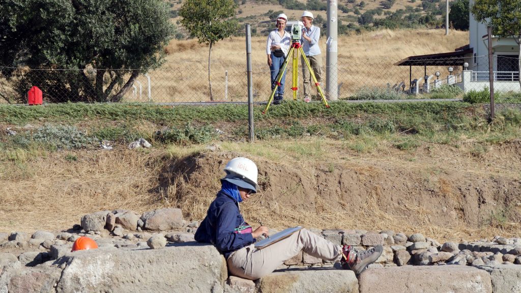
Surveys conducted at the site since 2009 accomplished not only the systematic documentation of archaeological finds such as architectural fragments, pottery and tile pieces, but also geophysical prospections and geographical investigations. Among the architectural fragments are two Attic bases, a Corinthian capital, an Ionic marble cornice, a base molding, a molding fragment with floral cymatium, a column and a column base. Besides andesite and limestone, the majority of architectural finds are marble and point to a middle-size marble architecture. On the other hand, certain architectural elements with different dimensions may point to more than one building at the site and the architectural fragments in general indicate various functions and building styles. According to the available architectural data, it may be possible to speak of a larger building complex consisting of more than one building at the site.
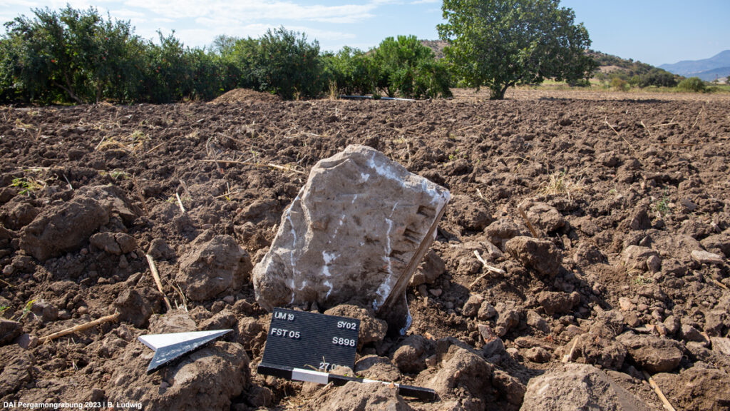
Meanwhile, potsherds and tiles observed and analyzed via intensive and extensive surveys indicate a date from the late Hellenistic to the late Byzantine Period (end of 2nd century BC – 13-15th century AD). Roman Imperial period sigillata sherds were found to be predominant in the pottery distribution. Pottery samples observed and collected at the site are of tableware, cooking vessels, storage vessels and vessels used for transport, which are reminiscent of pottery finds recovered from households. In addition to architectural finds and pottery, a votive relief of white marble was also discovered at the site already in 2009. It is impossible to give an exact dating due to deterioration on the surface, but the seated figure on the relief can be interpreted as Meter-Cybele.
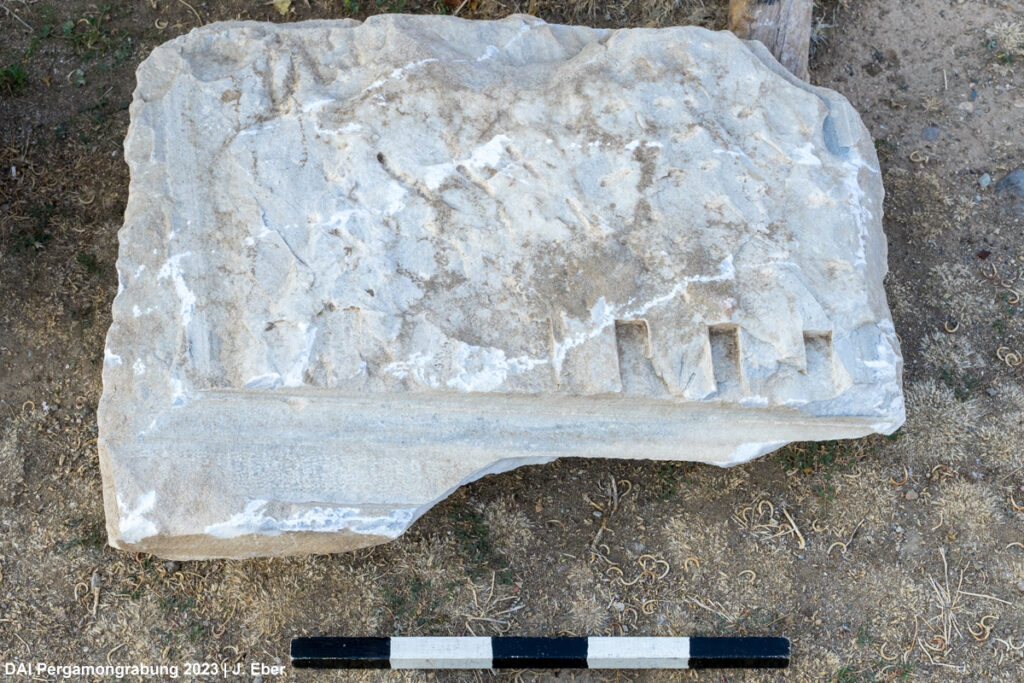
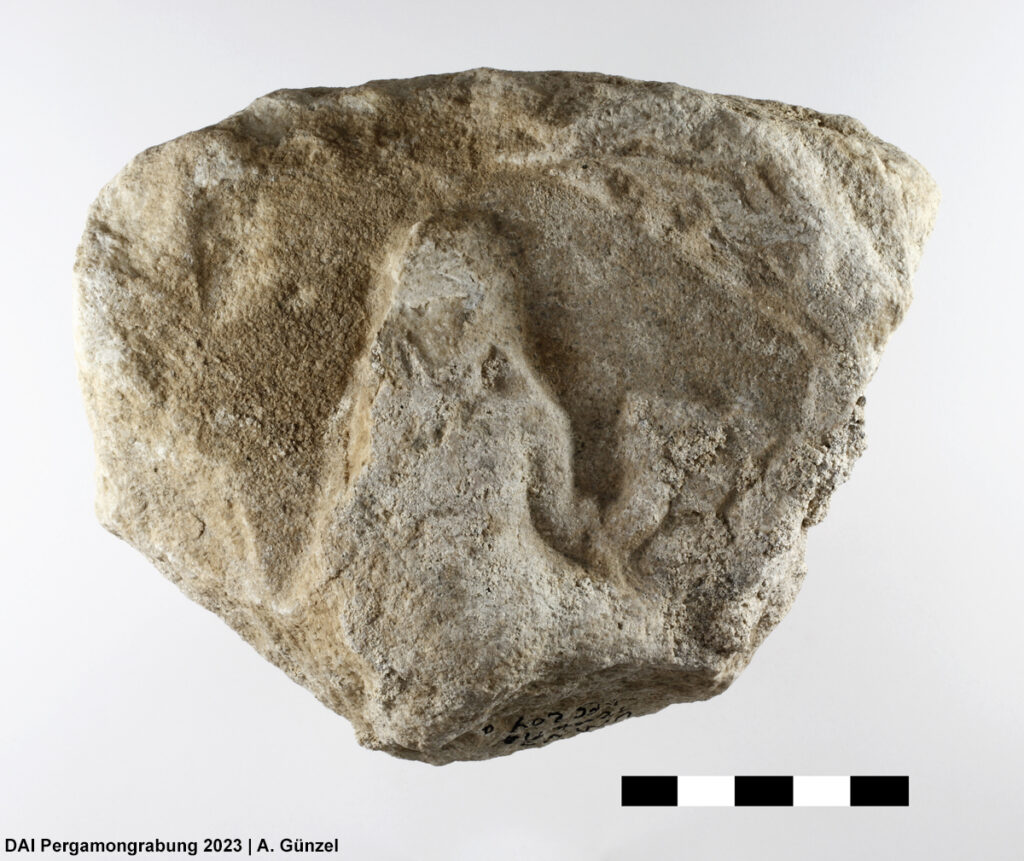
Fig. 4 (right) Fragment of a white marble relief.
Geophysical prospections revealed a building complex which is roughly 175 x 100 m in dimensions. The layout and extent of the building is also confirmed by the distribution and density of pottery and tiles. Oriented in northeast-southwest direction, the building possesses a courtyard surrounded by several spaces/rooms with various dimensions at the northern part, while further walls and spaces at the southern part make up a probable extension or a completely different structure perhaps with a different function and time of origin. Evidence coming from architectural fragments and pottery indicate a date from the Late Hellenistic to Byzantine Period and thus point to several phases and perhaps different functions of the buildings over time. Therefore, several scenarios have been put forward about the function of the site since its first discovery. Of these, a rural residence, perhaps a villa that dates to the Roman Period, seems promising due to several factors. First of all, the general plan of the building is reminiscent of a courtyard type of villa encountered in many places throughout the Roman world. In addition, geoarchaeological investigations demonstrate that the site was located on an elevated position within the plain, between two fluvial channels in the western lower Bakırçay plain, where fertile lands must have been used for the production of agricultural goods. Moreover, a route between Pitane and Pergamon passed immediately west of the site, which indicates the carefully chosen position of the site in terms of transport, which is also quite indicative for Roman villas in general.
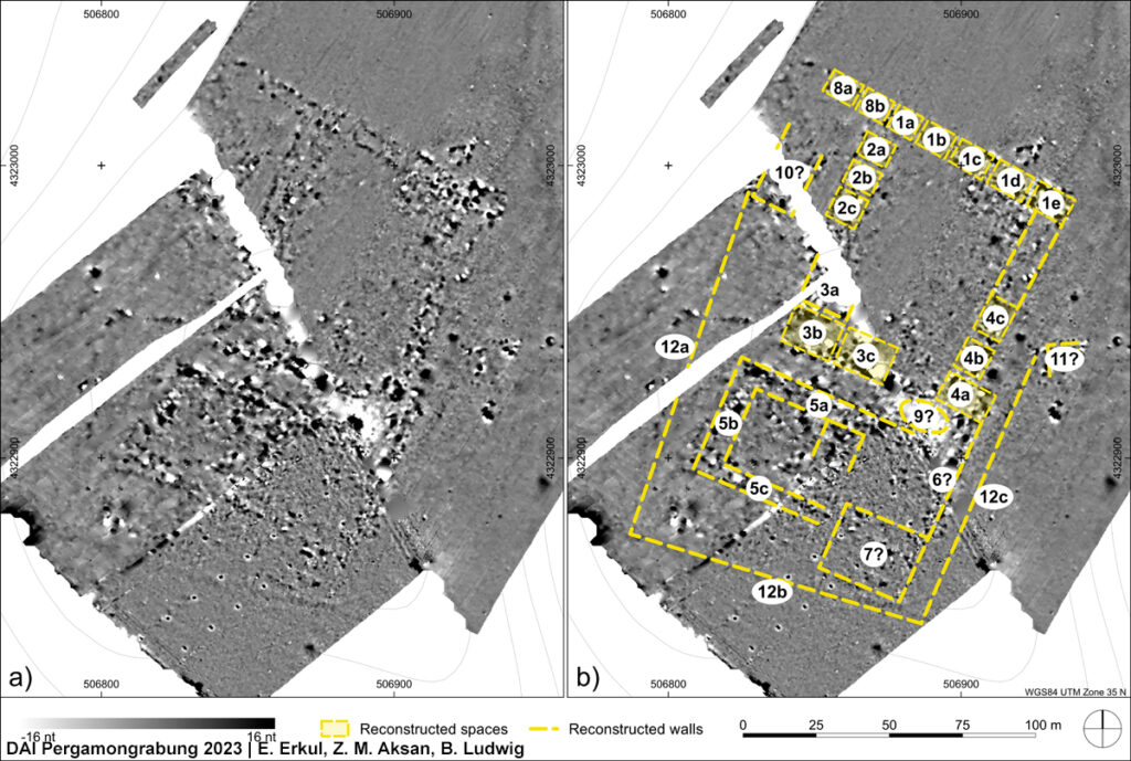
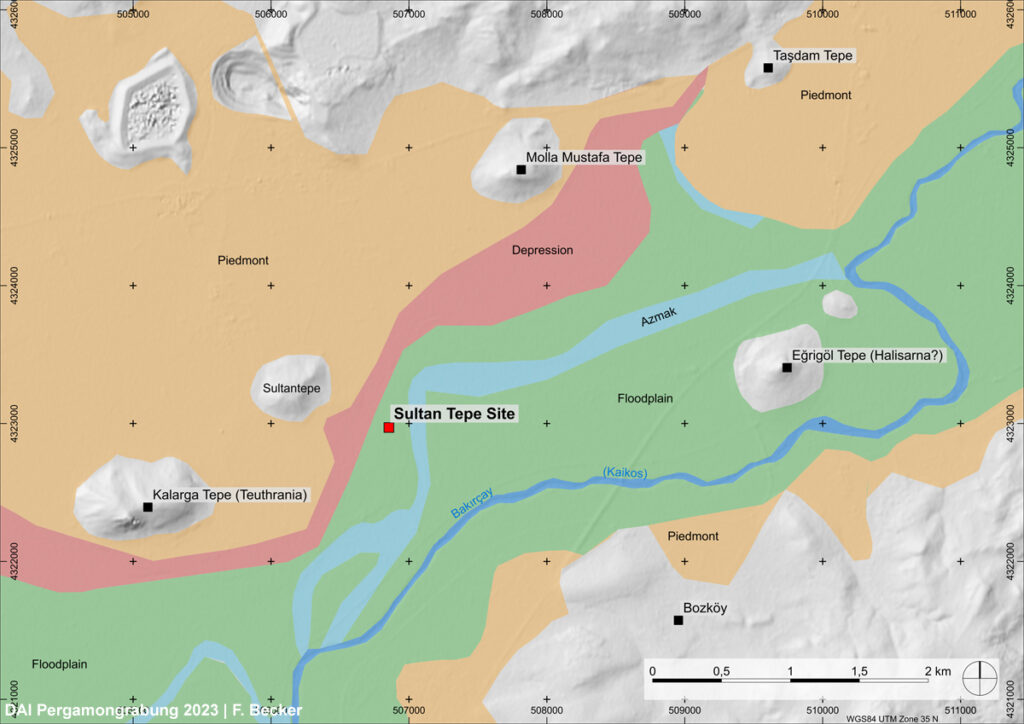
Fig. 6 (right) Map showing the paleoenvironmental situation in the vicinity of the Sultan Tepe site.
Meanwhile, part of the plan obtained from geomagnetic prospections can also be interpreted in favor of a rural sanctuary. Oriented in northwest-southeast direction, the building complex would measure about 42 x 64 m. The location of such a structure on a main route between Pergamon and Pitane, on a slightly elevated position are meaningful indicators in support of this view. Not only that, as clearly demonstrated via geomagnetic prospections, the orientation of the building is quite noteworthy. The building is oriented towards Sultan Tepe hill on the northwest, while its southeastern direction points directly towards the sanctuary of Meter at Mamurt Kale, a very prominent rural sanctuary during the Hellenistic Period with a ground plan similar to the assumed sanctuary at Sultan Tepe site. Presence of a marble votive relief also indicates cult activities at the site, which could be performed in domestic or productive spaces though and do not require a sanctuary. The architectural fragments and pottery finds do not provide clear evidence for a sanctuary, but do not exclude it neither.
Functioning of the building as a mansio or a caravanserai can also be discussed in terms of architectural layout of a part of the plan provided by geomagnetic prospections, as well as the location of the site in general. It is possible to find similar plans of mansiones with a courtyard surrounded by spaces/rooms in the Mediterranean during the Roman Period. The situation of the building on a possible route between Pergamon and Pitane is also quite noteworthy in this aspect. The site could have been used by people traveling towards Pergamon or vice versa as a stopping/resting place. Such a function can be well imagined in combination with a sanctuary.
Of the several possible functions of the site, the lime kiln scenario rests on the interpretation of some anomalies in the geomagnetic prospections as lime kilns. In addition, evidence of numerous burnt marble fragments found during the surveys may support this view. Although an exact date cannot be given for the lime kilns, a date in the Late Antiquity or Byzantine Period seems more plausible for this function, where remains of preceding building(s) could have been used to produce lime.
The presence of a burial ground with a probable tumulus in close proximity further raises the significance of the site in general. Besides honoring the dead and indicating a certain status among the community, tumulus burials in antiquity also played a role as significant landmarks in the landscape. The burials also indicate the presence of people with strong and probably long-lasting bonds to the site.
It is worth to underline the fact that the date obtained from pottery finds seem to be continuous from the late Hellenistic to the Byzantine Period. In addition to that, architectural finds do speak in favor of more than one building with possible various functions. Therefore, surface finds may reflect the possibility of diachronic layers at the site. The results from the geophysical prospections may also be used in favor of this supposition. The overlay of diachronic structures and/or functions of the site prevent us to make exact interpretations, which is in the nature of archaeological surveys. Be that as it may, of the several scenarios mentioned above, the villa function of the site seems to be more likely. The typology of the architectural fragments, pottery finds, the economic potential of the vicinity of the site and the longue durée may be used as key factors for this proposition. Nonetheless, the possibility of a sanctuary is still valid for the reasons mentioned above and should not be completely ruled out. In addition, a mansio or perhaps a caravanserai in a later period is also among the possibilities. Without excavation, it is not possible to say with certainty how many buildings there were at the Sultan Tepe site, when these buildings were built and for what purpose they were used.
The significant aspects of the investigation at Sultan Tepe are first of all its interdisciplinary approach and secondly, its non-invasive character, such as excavation. Through archaeological survey, geophysical measurements and geographers’ analyses, it was possible to propose different scenarios about the function of the archaeological site and its immediate landscape. Of course, it would have been possible to obtain much more satisfactory information if excavation had been carried out. But at the same time, more questions would have arisen than at present. In the end, the results of interdisciplinary investigations conducted without excavation have provided important data on the historical development of the site at Sultan Tepe as well as on the utilization of the landscape in the hinterland of Pergamon.
—
The related publication will be published in the next issue of ‘Istanbuler Mitteilungen’ under the following title: The Sultan Tepe Site and its Surroundings in the Western Lower Bakırçay Plain: A Rural Residence in the Pergamon Micro-Region? by Zeki Mete Aksan, Bernhard Ludwig, Güler Ateş, Annika Skolik, Fabian Becker, Ercan Erkul, Wolfgang Rabbel, Jörn Lang, Sarah Al Jarad, Felix Pirson, Brigitta Schütt
—